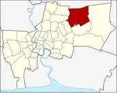
Khlong Sam Wa
| Khlong Sam Wa คลอง สาม วา |
|
|---|---|
| Data | |
| Province: | Bangkok |
| Surface: | 110.686 km² |
| Residents: | 174,197 (2013) |
| Population density : | 1125 U / km² |
| ZIP : | 10510 |
| Geocode : | 1046 |
| map | |

|
|
| Bangkok boroughs | |
Khlong Sam Wa ( Thai คลอง สาม วา , kʰlɔ̄ːŋ sǎːm wāː ) is one of the 50 khet (districts) in Bangkok , the capital of Thailand .
geography
The neighboring districts are clockwise from the north: Amphoe Lam Luk Ka of Pathum Thani Province and the Khet of Bangkok Nong Chok , Min Buri , Khan Na Yao , Bang Khen and Sai Mai .
history
Khlong Sam Wa was established as a district on November 21, 1997 by separating it from Min Buri. Khlong Sam Wa was the name of the amphoe in Min Buri and has kept that name ever since.
Since the turn of the millennium, Khlong Sam Wa has been one of the fastest growing districts in Bangkok in terms of population. The population doubled from 95,481 in 2000 to 189,507 in 2016.
Attractions
administration
The district is divided into the following five sub-districts ( Khwaeng ) :
| No. | Name Khwaeng | Thai | Pop. |
|---|---|---|---|
| 1. | Sam Wa Tawan Tok | สาม วา ตะวันตก | 51,473 |
| 2. | Sam Wa Tawan Ok | สาม วา ตะวันออก | 24,547 |
| 3. | Bang chan | บางชัน | 72,162 |
| 4th | Sai Kong Din | ทราย กอง ดิน | 10,436 |
| 5. | Sai Kong Din Tai | ทราย กอง ดิน ใต้ | 15,579 |
Municipal council
The Khlong Sam Wa district council has seven members, each member is elected for four years. The last election was on April 30, 2006. The results:
- Thai Rak Thai Party - 7 seats
Individual evidence
- ↑ 2013 population statistics ( Thai ) Department of Provincial Administration. Retrieved August 5, 2014.
Web links
- "Khlongsamwa District Office" (in Thai)
Coordinates: 13 ° 52 ' N , 100 ° 42' E
