Suan Luang
| Suan Luang สวนหลวง |
|
|---|---|
| Data | |
| Province: | Bangkok |
| Surface: | 23.678 km² |
| Residents: | 116,688 (2013) |
| Population density : | 4854 E./km² |
| ZIP : | 10250 |
| Geocode : | 1034 |
| map | |

|
|
| Bangkok boroughs | |
Suan Luang ( Thai : สวนหลวง , Royal Orchard ) is one of the 50 districts ( Khet ) of Bangkok , the capital of Thailand .
geography
The neighboring districts are clockwise from the north: Bang Kapi , Saphan Sung , Prawet , Phra Khanong and Watthana .
history
Suan Luang was originally part of a subdistrict of Phra Khanong . When Phra Khanong was divided into smaller districts on November 9, 1989, Suan Luang became part of the new Prawet district. On January 14, 1994 Suan Luang received its own district status, while parts of the Prawet and Watthana districts were incorporated in addition to the former Suan Luang subdistrict .

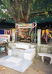
Mae Nak Shrine at Wat Maha Bud, Sukhumvit Soi 77, Suan Luang.
Attractions
- Wat Maha Bud - Buddhist temple ( Wat ) known for the Mae-Nak shrine on its grounds. This shrine is dedicated to Mae Nak , the spirit of a woman who died in childbed. Numerous novels and films, for example the successful " Spirit of Mae Nak ", were inspired by Mae Nak (see web links).
administration
The district has only one sub-district ( Khwaeng ) :
| No. | Name Khwaeng | Thai | Pop. |
|---|---|---|---|
| 1. | Suan Luang | สวนหลวง | 116,688 |
Individual evidence
- ↑ 2013 population statistics ( Thai ) Department of Provincial Administration. Retrieved August 5, 2014.
Web links
- Suan Luang District Office (in Thai)
- History and pictures of the film "Nang Nak" (in German)
Coordinates: 13 ° 44 ' N , 100 ° 39' E