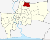
Sai Mai
| Sai Mai สายไหม |
|
|---|---|
| Data | |
| Province: | Bangkok |
| Surface: | 44.615 km² |
| Residents: | 191,536 (2013) |
| Population density : | 3649 U / km² |
| ZIP : | 10220 |
| Geocode : | 1042 |
| map | |

|
|
| Bangkok boroughs | |
Sai Mai ( Thai : สายไหม ) is one of the 50 khet (districts) in Bangkok , the capital of Thailand .
geography
The neighboring districts are clockwise from the north: Amphoe Lam Luk Ka in Pathum Thani Province and the following Khet of Bangkok : Khlong Sam Wa , Bang Khen , Lak Si and Don Mueang .
history
Sai Mai was originally the name of a Muban in Tambon Khu Khot (Amphoe Lam Luk Ka of Pathum Thani Province). It was transferred to Bang Khen Amphoe , then given tambon status in 1940. Due to the rapid population growth in this area, Sai Mai was promoted to khet on October 14, 1997 in order to improve the service of the administration.
Attractions
- Wat Amarawanaram
administration
Sai Mai is divided into three sub-districts ( Khwaeng ) :
| No. | Name Khwaeng | Thai | Pop. |
|---|---|---|---|
| 1. | Sai Mai | สายไหม | 74,696 |
| 2. | O Ngoen | ออ เงิน | 32,386 |
| 3. | Khlong Thanon | คลอง ถนน | 84,454 |
Municipal council
The Sai Mai district council has eight members, each member is elected for four years. The last election was on April 30, 2006. The results:
- Thai Rak Thai Party - 8 seats
Individual evidence
- ↑ ประกาศ กระทรวง มหาดไทย เรื่อง เปลี่ยนแปลง พื้นที่ เขต บางเขน เขต ลาดพร้าว เขต บึงกุ่ม เขต ประเวศ และ ตั้ง เขต สายไหม เขต เขต คันนายาว เขต สะพาน สูง . In: Royal Gazette . 114, No. พิเศษ 108 ง , November 18, 1997, p. 6.
- ↑ 2013 population statistics ( Thai ) Department of Provincial Administration. Retrieved August 6, 2014.
Web links
- "Saimai District Office" (in Thai)
Coordinates: 13 ° 54 ' N , 100 ° 40' E