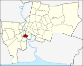
Bang Kho Laem
| Bang Kho Laem บางคอแหลม |
|
|---|---|
| Data | |
| Province: | Bangkok |
| Surface: | 10.921 km² |
| Residents: | 93,508 (2013) |
| Population density : | 9,727 U / km² |
| ZIP : | 10120 |
| Geocode : | 1031 |
| map | |

|
|
| Bangkok boroughs | |
Bang Kho Laem ( Thai : บางคอแหลม , bāːŋ kʰɔ̄ː lɛ̌ːm ) is one of the 50 districts (Khet) in Bangkok , the capital of Thailand . Bang Kho Laem is a southern city district on the east bank of the Mae Nam Chao Phraya ( Chao Phraya River ).
geography
Bang Kho Laem is located on a bend of the Mae Nam Chao Phraya, which flows around the district from the northwest, west and south. In the north, the district is bounded by Khlong Kruai, Phai Ngoen Road and Soi Wat Phai Ngoen, and in the east by Sathu Pradit Road and Chaloem Maha Nakhon Expressway .
The neighboring districts are clockwise from the north: Sathon and Yan Nawa as well as Rat Burana , Thonburi and Khlong San (the last three are on the other side of the Mae Nam Chao Phraya).
history
Bang Kho Laem was originally part of the Ban Thawai District ( Amphoe ) in Phra Pradaeng Province . Ban Thawai was later subordinated to Phra Nakhon Province and renamed Yan Nawa . In 1972 the provinces of Thonburi and Phra Nakhon were merged to form "Krung Thep Maha Nakhon" (also Bangkok), with Bang Khae becoming a subdistrict of Phasi Charoen . The administrative units of the new capital were retained, only the amphoe was renamed Khet and the tambon in Khwaeng , so the amphoe Yan Nawa ( อำเภอ ยานนาวา ) became the Khet Yan Nawa ( เขต ยานนาวา ).
A branch of the Yan Nawa District Office was established on April 18, 1989 to overlook the three sub-districts of Bang Kho Laem, Wat Phraya Krai, and Bang Khlo. On November 9, 1989, this branch became a separate district called Bang Kho Laem.
Attractions
- The Krungthep Bridge (English: "Bangkok Bridge") was opened on June 25, 1959 as the second bridge over the Chao Phraya.
- Asiatique The Riverfront is a leisure complex on the banks of the Chao Phraya, with restaurants, shops, and a ferris wheel . Around 1900 the area was a pier for the teak trade of the Danish Østasiatiske Kompagni . The current commercial buildings imitate the appearance of the old harbor warehouses. The facility is mainly frequented in the evening hours.
administration
The district is divided into three sub-districts ( Khwaeng ) :
| No. | Name Khwaeng | Thai | Pop. |
|---|---|---|---|
| 1. | Bang Kho Laem | บางคอแหลม | 25,645 |
| 2. | Wat Phraya Kri | วัด พระยา ไกร | 28,399 |
| 3. | Bang Khlo | บาง โค ล่ | 39,464 |
Individual evidence
- ↑ 2013 population statistics ( Thai ) Department of Provincial Administration. Retrieved August 5, 2014.
Web links
- BMA website with the tourist attractions of Bang Kho Laem ( Memento from September 30, 2007 in the Internet Archive ) (in English; WebArchive)
- Bangkholaem District Office (in Thai)
Coordinates: 13 ° 42 ' N , 100 ° 30' E