Bangkok Yai
| Bangkok Yai บางกอกใหญ่ |
|
|---|---|
| Data | |
| Province: | Bangkok |
| Surface: | 6.18 km² |
| Residents: | 71,087 (2013) |
| Population density : | 13,342.2 U / km² |
| ZIP : | 10600 |
| Geocode : | 1016 |
| map | |

|
|
| Bangkok boroughs | |
Bangkok Yai ( Thai บางกอกใหญ่ , bāːŋkɔ̀ːk jàj ) is one of the 50 khet (districts) in Bangkok , the capital of Thailand . Bangkok Yai is a central district on the west bank of the Mae Nam Chao Phraya ( Chao Phraya River ).
The name of this district is still used abroad for the capital of Thailand, even if it is officially called Krung Thep Maha Nakhon.
geography
Bangkok Yai is bounded in the north by the Khlong Mon ( คลอง มอญ , named after the ethnic group of the Mon ), in the east by the Mae Nam Chao Phraya and by the Khlong Bangkok Yai ( คลอง บางกอกใหญ่ ), in the south and in the west also by the Khlong Bangkok Yai.
The neighboring districts are clockwise from the north: Bangkok Noi , Phra Nakhon (on the other bank of the Mae Nam Chao Phraya), Thonburi , Phasi Charoen and Taling Chan .
history
The name of the district comes from the Khlong Bangkok Yai ( Thai : คลอง บางกอกใหญ่ ). This khlong ( canal ) used to be the Chao Phraya itself, which made a wide arc of about 15 km in length. The king of Ayutthaya probably had a canal dug as early as 1522 in order to shorten the travel time of merchant ships from the Gulf of Thailand to the port of Ayutthaya . In the course of time, the old riverbed silted up more and more, the banks moved closer and closer together, while the new canal grew to its current width. This also explains why the name of a small village - Bangkok ( wild plum village ) - is used for an area that lies on both sides of such a mighty river.
Bangkok Yai, or more precisely the Tambon Wat Arun , was also the founding area of the temporary capital of the Siamese Empire Thonburi , which existed here from 1767 to 1782.
The name of this district has been changed several times in the course of the last century until it was finally given its current name - Bangkok Yai - in the administrative reform of 1972.
Attractions
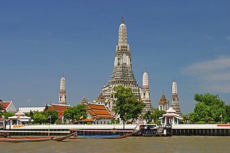
- The main attraction of Bangkok Yai is Wat Arun .
- Wang Derm Palace - historical palace of King Taksin , not open to tourists.
Other worth seeing Buddhist temples ( Wat ) :
- Wat Hong Rattanaram - restored temple from the Thonburi period
- Wat Khruea Wan - Ayutthaya temple in Chinese style
- Wat Molilokkayaram - a temple steeped in history next to the Wang Derm Palace
- Wat Ratchasittharam - worth seeing wall paintings in the Ubosot
traffic
The Bangkok Metro (MRT) blue line runs through the district with itsaraphap , Tha Phra and Charan 13 stations . On the Chao Phraya River there is a ferry connection between Tha Tian (at Wat Pho on the Rattanakosin Island) and Wat Arun.
administration
The district is divided into two sub-districts ( Khwaeng ) :
| No. | Name Khwaeng | Thai | Pop. |
|---|---|---|---|
| 1. | Wat Arun | วัด อรุณ | 14,628 |
| 2. | Wat Tha Phra | วัด ท่าพระ | 56,459 |
Individual evidence
- ↑ 2013 population statistics ( Thai ) Department of Provincial Administration. Retrieved August 5, 2014.
Web links
- Phra Racha Wang Derm - The "Old Palace" of King Taksin (in English and Thai)
- Bangkokyai District Office (in Thai)
Coordinates: 13 ° 43 ' N , 100 ° 29' E
