Council Burana
| Council Burana ราษฎร์บูรณะ |
|
|---|---|
| Data | |
| Province: | Bangkok |
| Surface: | 15.782 km² |
| Residents: | 85,825 (2013) |
| Population density : | 6012 U./km² |
| ZIP : | 10140 |
| Geocode : | 1024 |
| map | |

|
|
| Bangkok boroughs | |
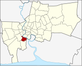
Council Burana ( Thai : ราษฎร์บูรณะ ) is one of the 50 khet (districts) in Bangkok , the capital of Thailand . Council Burana is located in the extreme south of the urban area.
geography
The district of Rat Burana is bounded in the north by a short piece of the Khlong Dao Khanong and by the Mae Nam Chao Phraya ( Chao Phraya River ), in the east by a small piece of the Khlong Chaeng Ron, then the border runs seemingly arbitrarily through one "Low Residential Zone", until it is formed again in the west by Khlongs, the Khlong Yai Jamphii and the Khlong Bang Phakaeo, until it meets Suksawat Road. Suksawat Road forms the rest of the western border for a few 100 meters until it meets the Khlong Dao Khanong again.
Neighboring districts clockwise from the north: Thonburi , then on the other bank of the Mae Nam Chao Phraya Bang Kho Laem and Yan Nawa , in the east is Amphoe Phra Pradaeng (in the province of Samut Prakan ), furthermore Thung Khru and Chom Thong .
history
When King Taksin established Thonburi as the new capital of Siam , the area of Rat Burana formed the border area. Later administrative changes brought Council Burana as a district ( Amphoe ) to Thonburi Province, later to the Phra Pradaeng Province, which no longer exists today . When this was dissolved in 1932 and largely incorporated into Samut Prakan Province , the district came back to Thonburi Province. With the merging of the provinces Thonburi and Phra Nakhon to form the city of Bangkok, Burana became part of the city on the advice of Burana. In 1998, part of the amphoe was separated to form the Thung Khru District .
transport
The four main khlongs (canals) in Council Burana are
- Khlong Chaeng Ron
- Khlong Council Burana
- Khlong Bang Phakok
- Khlong Bang Phakaeo
The following main roads are in Council Burana:
- Thanon Suksawat with 25 public and 17 private sois (side streets).
- Thanon Council Burana with 14 public and 23 private sois.
- Thanon Council Pattnan with 5 public sois.
- Thaon Pracha U-thit with 21 public and 13 private sois.
The Chalerm Maha Nakhon Expressway also runs through the district. It runs from Chom Thong District over Rama IX Bridge to Bang Na District , where it meets Sukhumvit Road . The extension forms the Bang Na Expressway . The expressway is subject to toll , it received the ISO 9002 certificate for "Service Quality Management of its toll collection service" from TÜV Rheinland Thailand Ltd. (TUV), valid for the period from May 19, 2000 to May 18, 2003.
Attractions
There are a total of seven Buddhist temples ( wat ) in the Rat Buana district , including:
- Wat Prasoet Sutthawat (Thai: วัด ประเสริฐ สุทธาวาส ) - an ancient temple in Chinese style from the Ayutthaya period . Worth seeing are the wall paintings in the Ubosot in black ink, which tell the "legend of the three kingdoms". The wall paintings were made under King Rama III. renovated.
- Wat Chaeng Ron (Thai: วัด แจงร้อน ) - an old temple from the U Thong ( Lop-Buri ) period, in the Wihan a U-Thong Buddha statue made of sandstone, called Luang Phor Hin Daeng.
- Wat Bang Pakok (Thai: วัด บาง ปะ กอก ) - temple with a Mon style chedi built in the early Rattanakosin period.
- Wat Rat Burana (Thai:วัด ราษฎร์บูรณะ ) - this temple houses a sandstone Buddha statue from the Ayutthaya period, which is said to be the oldest statue in the Rat Burana district.
administration
The district is divided into two sub-districts ( Khwaeng ) :
| No. | Name Khwaeng | Thai | Pop. |
|---|---|---|---|
| 1. | Council Burana | ราษฎร์บูรณะ | 34,430 |
| 2. | Bang Pa Kok | บาง ปะ กอก | 51,395 |
Individual evidence
- ↑ 2013 population statistics ( Thai ) Department of Provincial Administration. Retrieved August 5, 2014.
Web links
- Council Burana District Office (in Thai)
Coordinates: 13 ° 41 ′ N , 100 ° 30 ′ E