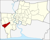
Bang bon
| Bang Bon บาง บอน |
|
|---|---|
| Data | |
| Province: | Bangkok |
| Surface: | 34.745 km² |
| Residents: | 106,085 (2013) |
| Population density : | 2723.75 U / km² |
| ZIP : | 10150 |
| Geocode : | 1050 |
| map | |

|
|
| Bangkok boroughs | |
Bang Bon ( Thai : บาง บอน , pronunciation: [bāːŋ bɔ̄ːn] ) is one of the 50 districts (Khet) in Bangkok , the capital of Thailand .
geography
The neighboring districts are clockwise from the north: Bang Khae , Phasi Charoen , Chom Thong and Bang Khun Thian , in the province of Samut Sakhon are Amphoe Mueang Samut Sakhon and Amphoe Krathum Baen . To the northwest of Bang Bon is Nong Khaem , again a khet from Bangkok.
history
Originally - before Thonburi and Phra Nakhon were merged into one province - Bang Bon was a tambon of the district ( Amphoe ) Bang Khun Thian of Thonburi province. After that it became a subdistrict of Bang Khun Thian.
Effective October 14, 1997, Bang Bon was separated from the Bang Khun Thian District and became an independent district. The district administration started its work on March 6, 1998. Its district administration was the last to be reopened. It was initially located in the building of Thepphayada Arak Market before the new building opened on Ekachai Soi 135/1 (Suea To) on Ekachai Road.
Important temples
- Wat Bang Bon ( วัด บาง บอน )
economy
Agriculture is the biggest economic factor in Bang Bon. The best-known products are the Nam-Dok-Mai- Mangoes , coconuts , orchids and lotus blossoms .
administration
The district has only one sub-district ( Khwaeng ) :
| No. | Name of the Khwaeng | Thai | Pop. |
|---|---|---|---|
| 1. | Bang bon | บาง บอน | 106.085 |
Individual evidence
- ↑ 2013 population statistics ( Thai ) Department of Provincial Administration. Retrieved August 5, 2014.
Web links
- Bang Bon District Office (in Thai)
Coordinates: 13 ° 40 ′ N , 100 ° 25 ′ E