Bang Kapi
| Bang Kapi บางกะปิ |
|
|---|---|
| Data | |
| Province: | Bangkok |
| Surface: | 28.523 km² |
| Residents: | 149,056 (2013) |
| Population density : | 5185 U./km² |
| ZIP : | 10240, 10250 |
| Geocode : | 1006 |
| map | |

|
|
| Bangkok boroughs | |
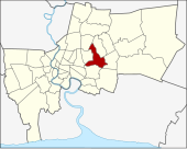
Bang Kapi ( Thai : บางกะปิ , pronunciation: [bāːŋ kàpìʔ] ) is one of the 50 districts (Khet) in Bangkok , the capital of Thailand . Bang Kapi is located in the eastern part of the city roughly between the streets (Thanon) Lat Phrao and Ramkhamhaeng.
geography
The neighboring districts are clockwise from the north: Bueng Kum , Saphan Sung , Prawet , Suan Luang , Huai Khwang , Wang Thonglang, and Lat Phrao .
history
In the past the area was a jungle , its history goes back to the reign of King Nangklao ( Rama III. ), When the general Chao Phraya Bodindecha ( เจ้าพระยา บดินทรเดชา ) fought insurgents in Champasak and Luang Prabang and brought settlers back from there.
Bang Kapi was originally a very large district. The area was greatly reduced in 1989 when the Lat Phrao and Bueng Kum districts were separated. It was downsized again on October 14, 1997 when Wang Thonglang and Saphan Sung counties were re-established.
education
- Ramkhamhaeng University
- Assumption University (private)
- National Institute of Development Administration
- Hua Mak Sports Complex with the Rajamangala National Stadium
shop
- The Mall Ramkhamhaeng
- The Mall Bang Kapi
transport
Express boats connect Bangkok's business center with “The Mall Bangkapi” via the Khlong Saen Saep .
administration
Bang Kapi is divided into two sub-districts ( Khwaeng ):
| No. | Name Khwaeng | Thai | Pop. |
|---|---|---|---|
| 1. | Khlong Chan | คลองจั่น | 82.045 |
| 2. | Hua Mak | หัวหมาก | 67.011 |
Municipal council
The Bang Kapi district council has eight members, each member is elected for four years. The last election was on April 30, 2006. The results:
- Democratic Party - 7 seats
- Thai Rak Thai Party - 1 seat
Individual evidence
- ↑ 2013 population statistics ( Thai ) Department of Provincial Administration. Retrieved August 5, 2014.
Web links
- BMA websites with the touristically interesting places of Bang Kapi ( Memento from September 30, 2007 in the Internet Archive ) (WebArchive)
- Bang Kapi District Office (in Thai)
Coordinates: 13 ° 46 ' N , 100 ° 39' E