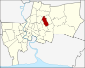
Bueng Kum
| Bueng Kum บึงกุ่ม |
|
|---|---|
| Data | |
| Province: | Bangkok |
| Surface: | 24.311 km² |
| Residents: | 145,822 (2013) |
| Population density : | 5690 U / km² |
| ZIP : | 10240, 10230 |
| Geocode : | 1027 |
| map | |

|
|
| Bangkok boroughs | |
Bueng Kum ( Thai บึงกุ่ม , bɯ̄ŋ kùm ) is one of the 50 districts (Khet) in Bangkok , the capital of Thailand . Bueng Kum is a district within the eastern suburb on Thanon Sukhapiban 1.
geography
The neighboring districts are clockwise from the north: Bang Khen , Khan Na Yao , Saphan Sung , Bang Kapi, and Lat Phrao .
etymology
Bueng Kum is named after a lake ( Bueng means "lake"), which is used as a retention basin during floods. In and around the lake there are many plants that Kum are called ( Crataeva hygrophila ). The lake is now part of the Seri Thai public park.
history
Bueng Kum was separated from Bang Kapi District on September 4, 1989, and then consisted of Khlong Kum, Khan Na Yao, and Saphan Sung sub-districts. On October 14, 1997, Khan Na Yao and Saphan Sung were made separate districts, so that at that time only Khlong Kum remained as a single sub-district.
On September 21, 2009, the Royal Gazette announced the establishment of two new subdistricts: Nuamin and Nuan Chan.
Attractions
- Seri Thai Park
administration
The district has three sub-districts ( Khwaeng ) :
| No. | Name Khwaeng | Thai | Pop. |
|---|---|---|---|
| 1. | Khlong Kum | คลอง กุ่ม | 70.085 |
| 2. | Navamin | นว มิ นท ร์ | 28,683 |
| 3. | Nuan Chan | นวลจันทร์ | 47.054 |
Municipal council
The Bueng Kum District Council has seven members, each member is elected for four years. The last election was on April 30, 2006. The results:
- Thai Rak Thai Party - seven seats
Individual evidence
- ↑ Announcement with sketch map in the Royal Gazette (PDF file in Thai)
- ↑ Seri Thai Park ( Memento of the original from August 5, 2014 in the Internet Archive ) Info: The archive link was inserted automatically and has not yet been checked. Please check the original and archive link according to the instructions and then remove this notice. - Website of the BMA, Public Park Office (in English and Thai)
- ↑ 2013 population statistics ( Thai ) Department of Provincial Administration. Retrieved August 5, 2014.
Web links
- Bueng Kum District Office (in Thai)
Coordinates: 13 ° 47 ' N , 100 ° 40' E