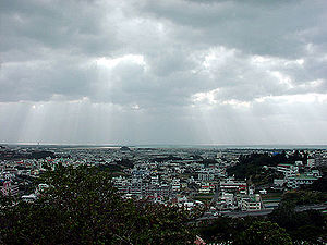
Tomigusuku
| Tomigusuku-shi 豊 見 城市 |
||
|---|---|---|
| Geographical location in Japan | ||
|
|
||
| Region : | Kyushu | |
| Prefecture : | Okinawa | |
| Coordinates : | 26 ° 10 ' N , 127 ° 40' E | |
| Basic data | ||
| Surface: | 19.25 km² | |
| Residents : | 63,700 (October 1, 2019) |
|
| Population density : | 3309 inhabitants per km² | |
| Community key : | 47212-3 | |
| Symbols | ||
| Flag / coat of arms: | ||
| Tree : | Diospyros ferrea | |
| Flower : | Bougainvillea | |
| town hall | ||
| Address : |
Tomigusuku City Hall 854 - 1 , Aza Onaga Tomigusuku -shi Okinawa 901-0292 |
|
| Website URL: | http://www.city.tomigusuku.okinawa.jp/ | |
| Location of Tomigusuku in Okinawa Prefecture | ||
Tomigusuku ( Japanese 豊 見 城市 , - shi ) is a Japanese city in Okinawa Prefecture . The name comes from the Ryūkyū language and would actually read Tomishiro in standard Japanese .
geography
The city lies between Naha , the capital of Okinawa, in the north and Itoman in the south, is 19.25 km² and in December 2006 had 54,177 inhabitants.
The quite quiet city consists mainly of single-family houses and some prefabricated buildings from the 50s and 60s and is growing very dynamically. Many of the old prefabricated buildings are continuously being torn down and replaced by new ones. Not least because of the growing prosperity of the community and the very low crime rate, the price of land is rising continuously.
Tomigusuku begins seamlessly on the Naha city limits, just south of Oroku District. In the 50s and 60s Tomigusuku was conceived and expanded as a “bed city” for Naha. Many of those who lived there worked in Naha. However, that has changed a lot over the years. Due to many construction projects, the city continued to grow and the flow of commuters to Naha decreased, as a comprehensive range of jobs and leisure activities in the city itself has been created and is being expanded. Therefore, Tomigusuku cannot be understood as a satellite city of Naha, but rather as an independent community with its own identity.
Apart from a few overflying Navy helicopters, the American military is not present in Tomigusuku.
history
On April 1, 2002 , the then largest village in Japan (today this is Takizawa in Iwate ) was given city status ( shi ) without being incorporated .
City arms
The coat of arms is believed to represent an abstract version of the bougainvillea that thrives almost everywhere in the region. Some residents claim, sometimes in jest, that the character “ と ” ( to ) “three times” (Japanese mi ) shows what “to mi” can be read for Tomi gusuku. For this reason, the bougainvillea was chosen as the city's flower.
traffic
The terrain is sometimes extremely hilly, which makes driving a car very difficult. There are only a few bus routes on public transport. The road network in the residential areas is sufficient, but confusing. At many bends and crossings there are viewing mirrors due to the narrowness. The main streets are always crowded during rush hour. Traffic jams are part of everyday life. Okinawa has one of the highest accident rates in Japan. This is not due to driving too fast, but rather to drink-driving and the large number of American soldiers who cannot cope with left-hand driving. The special briefing of the soldiers on the traffic system, which is a prerequisite for driving there, does not seem to be sufficient preparation. The Okinawa Expressway, a highway that forms the main traffic axis from north to south, is currently ( 2006 ) being extended via Tomigusuku to Itoman . In Tomigusuku itself, this highway is then led through several tunnels under the residential areas, which is also thanks to the mountainous landscape.
sons and daughters of the town
- Uehara Takako ( 上原 多 香 子 ; born January 14, 1983), actress and member of the Japanese pop group SPEED
Neighboring cities and communities
See also
Web links
- City Official Website (Japanese)
- Uehara Takako's website (Japanese)
- Maps, weather and airports (English)
- Tomigusuku "Uji Zome" Cooperative, Tourist Information ( Memento from September 28, 2007 in the Internet Archive ) (English)


