Urasoe
| Urasoe-shi 浦 添 市 |
||
|---|---|---|
| Geographical location in Japan | ||
|
|
||
| Region : | Kyushu | |
| Prefecture : | Okinawa | |
| Coordinates : | 26 ° 15 ' N , 127 ° 43' E | |
| Basic data | ||
| Surface: | 19.09 km² | |
| Residents : | 115,158 (October 1, 2019) |
|
| Population density : | 6032 inhabitants per km² | |
| Community key : | 47208-5 | |
| Symbols | ||
| Flag / coat of arms: | ||
| Tree : | Elaeocarpus sylvestris var.ellipticus | |
| Flower : | ||
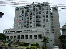
| town hall | ||
| Address : |
Urasoe City Hall 1 - 1 - 1 , Anhacha Urasoe -shi Okinawa 901-2501 |
|
| Website URL: | http://www.city.urasoe.lg.jp/ | |
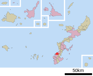
| Location of Urasoes in Okinawa Prefecture | ||
Urasoe ( Japanese 浦 添 市 , - shi ; Okinawan Urashī ) is a city on Okinawa Hontō in Okinawa Prefecture , Japan .
Urasoe is north of Naha .
history
From the 13th century to the early 15th century, Urasoe was the capital of the Principality of Chūzan . At that time, Urasoe Castle was the largest in Okinawa.
traffic
- Street
- Okinawa Highway
- National road 58,330
Town twinning
- Quanzhou (China)
Neighboring cities and communities
Personalities
- Taishi Sunagawa (born 1990), football player
Web links
Commons : Urasoe - collection of images, videos and audio files
- Official website in English


