Nago
| Nago-shi 名 護 市 |
||
|---|---|---|
| Geographical location in Japan | ||
|
|
||
| Region : | Kyushu | |
| Prefecture : | Okinawa | |
| Coordinates : | 26 ° 35 ' N , 127 ° 58' E | |
| Basic data | ||
| Surface: | 210.26 km² | |
| Residents : | 62,725 (October 1, 2019) |
|
| Population density : | 298 inhabitants per km² | |
| Community key : | 47209-3 | |
| Symbols | ||
| Flag / coat of arms: | ||
| Tree : | Banyan fig | |
| Flower : | Easter lily | |
| town hall | ||
| Address : |
Nago City Hall 1 - 1 - 1 , Minato Nago -shi Okinawa 905-8540 |
|
| Website URL: | http://www.city.nago.okinawa.jp/ | |
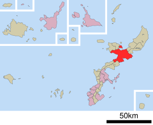
| Location Nagos in Okinawa Prefecture | ||
Nago ( Japanese 名 護 市 , - shi ) is a city on Okinawa Hontō in Okinawa Prefecture , Japan .
history
The city of Nago was founded on August 1, 1970 from the former parishes of Nago, Haji, Yabe, Yagaji, and Hisashi.
The 26th G8 summit took place here from July 21 to 23, 2000 .
Attractions
Near the city center, where in the 15th century, the castle Nago stand, is the sprawling "Nago Castle Park" (Jap .:名護城公園). With its many cherry trees, it is a popular place to admire the cherry blossom ( hanami ), which in Okinawa can begin as early as the end of January.
traffic
- Street:
- Okinawa Highway
- National roads 58, 329, 331, 449, 505
sons and daughters of the town
- Tokuda Kyūichi (1894–1953), communist politician
- Meisa Kuroki (* 1988), actress, model and singer
- Yūsuke Higa (* 1989), football player
Web links
Commons : Nago - collection of images, videos and audio files
- Official Website (Japanese)


