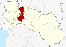
Bang Khla district
|
Bang Khla บางคล้า |
|
|---|---|
| Province: | Chachoengsao |
| Surface: | 227.9 km² |
| Residents: | 45,575 (2013) |
| Population density : | 204.2 U / km² |
| ZIP : | 24110 |
| Geocode : | 2402 |
| map | |

|
|
Amphoe Bang Khla (in Thai : อำเภอ บางคล้า ) is a district ( amphoe - administrative district) in the province of Chachoengsao . The Chachoengsao Province is located in the eastern part of the central region of Thailand .
geography
Neighboring districts (clockwise from east): Ratchasan District , Plaeng Yao , Ban Pho , Mueang Chachoengsao and Khlong Khuean in Chachoengsao Province and Ban Sang District in Prachin Buri Province .
The main river in the county is the Maenam Bang Pakong (Bang Pakong River).
history
Bang Khla was established in 1901, the administration building was in Wat Mai Bang Khla, which is now in Tambon Ban Suan. Ban Bang Khla is located on the Khlong (Canal) Bang Khla. When the administration was no longer in the center of the district, the government moved it to the Tambon Tao Sura, about three miles from the previous location. The name of the tambon was later changed to Bang Khla to match the name of the circle.
education
A sub- campus of the Rajabhat-Rajanagarindra University is located in Amphoe Bang Rachan .
administration
Provincial Administration
Bang Khla County is divided into nine tambon ("subdistricts" or "parishes"), which are further subdivided into 56 muban ("villages").
| No. | Surname | Thai | Muban | Pop. |
|---|---|---|---|---|
| 1. | Bang Khla | บางคล้า | - | 9.314 |
| 4th | Bang Suan | บาง สวน | 4th | 2.136 |
| 8th. | Bang Krachet | บาง กระ เจ็ด | 9 | 4,590 |
| 9. | Pak Nam | ปากน้ำ | 12 | 5,490 |
| 10. | Tha Thonglang | ท่า ทองหลาง | 6th | 4,605 |
| 11. | Sao Cha-ngok | สาว ชะโงก | 6th | 3.131 |
| 12. | Samet Nuea | เสม็ด เหนือ | 6th | 4,921 |
| 13. | Samet Tai | เสม็ด ใต้ | 6th | 5,043 |
| 14th | Hua Sai | หัวไทร | 7th | 6,345 |
Note: The missing geocodes refer to the tambon, which today belong to the Amphoe Khlong Khuean .
Local administration
There are two municipalities with "small town" status ( Thesaban Tambon ) in the district:
- Bang Khla (Thai: เทศบาล ตำบล บางคล้า ) consisting of the complete Tambon Bang Khla.
- Pak Nam (Thai: เทศบาล ตำบล ปากน้ำ ) consisting of the complete Tambon Pak Nam.
In addition, there are seven " Tambon Administration Organizations " ( องค์การ บริหาร ส่วน ตำบล - Tambon Administrative Organizations, TAO)
- Bang Suan (Thai: องค์การ บริหาร ส่วน ตำบล บาง สวน ) consisting of the complete Tambon Bang Suan.
- Bang Krachet (Thai: องค์การ บริหารส่วน ตำบล บาง กระ เจ็ด ) consisting of the complete Tambon Bang Krachet.
- Tha Thonglang (Thai: องค์การ บริหาร ส่วน ตำบล ท่า ทองหลาง ) consisting of the complete tambon Tha Thonglang.
- Sao Cha-ngok (Thai: องค์การ บริหาร ส่วน ตำบล สาว ชะโงก ) consisting of the complete tambon Sao Cha-ngok.
- Samet Nuea (Thai: องค์การ บริหาร ส่วน ตำบล เสม็ด เหนือ ) consisting of the complete Tambon Samet Nuea.
- Samet Tai (Thai: องค์การ บริหาร ส่วน ตำบล เสม็ด ใต้ ) consisting of the complete Tambon Samet Tai.
- Hua Sai (Thai: องค์การ บริหาร ส่วน ตำบล หัวไทร ) consisting of the complete Tambon Hua Sai.
Individual evidence
- ↑ 2013 population statistics ( Thai ) Department of Provincial Administration. Retrieved October 6, 2014.
Web links
- More details on Amphoe Bang Khla from amphoe.com (in Thai)
- History of Bang Khla District ( Memento of March 11, 2007 in the Internet Archive ) (in Thai)
Coordinates: 13 ° 44 ' N , 101 ° 12' E
