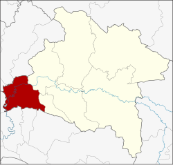
Ban Sang district
|
Ban Sang บ้าน สร้าง |
|
|---|---|
| Province: | Prachin Buri |
| Surface: | 361.2 km² |
| Residents: | 31,344 (2013) |
| Population density : | 85.3 U / km² |
| ZIP : | 25150 |
| Geocode : | 2506 |
| map | |

|
|
Amphoe Ban Sang ( Thai : อำเภอ บ้าน สร้าง ) is a district ( Amphoe - administrative district) in the west of the province of Prachin Buri . The province of Prachin Buri is located in the east of the central region of Thailand .
geography
Amphoe Bang San is bounded by the following amphoe (clockwise from the north): Amphoe Ongkharak , Mueang Nakhon Nayok and Pak Phli in Nakhon Nayok Province , Amphoe Mueang Prachin Buri and Si Mahosot in Prachin Buri Province, and Amphoe Ratchasan , Bang Khla , Khlong Khuean and Bang Nam Priao in Chachoengsao Province .
An important river in the county is the Maenam Prachin Buri ( Prachin Buri River , also called Maenam Bang Pakong ).
history
In the past, the area of what is now Ban Sang County was a dense jungle where wild elephants lived. Laotians from Vientiane settled here and named their settlement Ban Chang (literally: elephant village ). Later the name was changed to Ban Sang.
Ban Sang County was established in 1905.
administration
Provincial Administration
The district of Ban Sang is divided into nine tambon ("subdistricts" or "municipalities"), which are further subdivided into 88 muban ("villages").
| No. | Surname | Thai | Muban | Pop. |
|---|---|---|---|---|
| 1. | Ban Sang | บ้าน สร้าง | 11 | 5,582 |
| 2. | Bang Krabao | บาง กระเบา | 9 | 3,469 |
| 3. | Bang Toei | บางเตย | 10 | 2,779 |
| 4th | Bang Yang | บาง ยาง | 13 | 3,851 |
| 5. | Bang Taen | บาง แตน | 13 | 4,417 |
| 6th | Bang Phluang | บาง พลวง | 11 | 5,693 |
| 7th | Bang Pla Ra | บาง ปลาร้า | 8th | 2.406 |
| 8th. | Bang Kham | บาง ขาม | 6th | 1,722 |
| 9. | Krathum Phaeo | กระทุ่ม แพ้ ว | 7th | 1,425 |
Local administration
There is one municipality with "small town" status ( Thesaban Tambon ) in the district:
- Ban Sang (Thai: เทศบาล ตำบล บ้าน สร้าง ) consisting of the parts of the Tambon Ban Sang, Bang Krabao.
In addition, there are seven " Tambon Administration Organizations " ( องค์การ บริหาร ส่วน ตำบล - Tambon Administrative Organizations, TAO)
- Ban Sang (Thai: องค์การ บริหาร ส่วน ตำบล บ้าน สร้าง ) consisting of parts of the Tambon Ban Sang.
- Bang Krabao (Thai: องค์การ บริหาร ส่วน ตำบล บาง กระเบา ) consisting of parts of the Tambon Bang Krabao.
- Bang Toei (Thai: องค์การ บริหาร ส่วน ตำบล บางเตย ) consisting of the complete Tambon Bang Toei.
- Bang Yang (Thai: องค์การ บริหาร ส่วน ตำบล บาง ยาง ) consisting of the complete Tambon Bang Yang.
- Bang Taen (Thai: องค์การ บริหาร ส่วน ตำบล บาง แตน ) consisting of the complete Tambon Bang Taen.
- Bang Phluang (Thai: องค์การ บริหาร ส่วน ตำบล บาง พลวง ) consisting of the complete Tambon Bang Phluang.
- Bang Pla Ra (Thai: องค์การ บริหาร ส่วน ตำบล บาง ปลาร้า ) consisting of the complete tambon Bang Pla Ra, Bang Kham, Krathum Phaeo.
Individual evidence
- ↑ 2013 population statistics ( Thai ) Department of Provincial Administration. Retrieved October 10, 2014.
Web links
Coordinates: 14 ° 0 ' N , 101 ° 13' E
