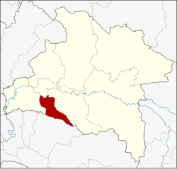
Si Mahosot district
|
Si Mahosot ศรี ม โห ส ถ |
|
|---|---|
| Province: | Prachin Buri |
| Surface: | 130.830 km² |
| Residents: | 18,495 (2013) |
| Population density : | 138.6 U / km² |
| ZIP : | 25190 |
| Geocode : | 2509 |
| map | |

|
|
Amphoe Si Mahosot ( Thai : อำเภอ ศรี ม โห ส ถ ) is a district ( Amphoe - Administrative District) in the Province of Prachin Buri . The province of Prachin Buri is located in the east of the central region of Thailand .
geography
Amphoe Si Mahosot is bounded by the following Amphoe (clockwise from the north): Ban Sang , Mueang Prachin Buri and Si Maha Phot in Prachin Buri Province and Phanom Sarakham Amphoe in Chachoengsao Province .
history
About 2000 years ago, a sapling of a tree is said to have been brought from India to Si Mahosot, which was planted at Wat Ton Pho Si Maha Pho and which today is the largest bodhi tree in the country with a circumference of 20 m and a height of 30 m . During the Dvaravati period there was an important settlement near Khok Pip, the remains of which can still be found today on an area of more than 100 hectares . It usually is Hindu buildings and facilities, such as ditches and laterite - stupas .
Si Mahosot was set up on February 15, 1970, initially as a "branch circle" ( King Amphoe ) with the name Khok Pip, by separating the three tambon Khok Pip, Khu Lam Phan and Phai Cha Lueat from the Amphoe Si Maha Phot . On April 13, 1977, it got full amphoe status. On June 3, 1993, Khok Pip was renamed Si Mahosot.
administration
Provincial Administration
The district of Si Mahosot is divided into four tambon ("subdistricts" or "municipalities"), which are further subdivided into 26 muban ("villages").
| No. | Surname | Thai | Muban | Pop. |
|---|---|---|---|---|
| 1. | Khok Pip | โคกปีบ | 9 | 8,970 |
| 2. | Khok Thai | โคก ไทย | 9 | 6,514 |
| 3. | Khu Lam Phan | คู้ ลำ พัน | 4th | 1,174 |
| 4th | Phai Cha Lueat | ไผ่ ชะ เลือด | 4th | 1,837 |
Local administration
There is one municipality with "small town" status ( Thesaban Tambon ) in the district:
- Khok Pip (Thai: เทศบาล ตำบล โคกปีบ ) consisting of the parts of the tambon Khok Pip, Khok Pip.
There are also three " tambon administration organizations " ( องค์การ บริหาร ส่วน ตำบล - Tambon Administrative Organizations, TAO)
- Khok Pip (Thai: องค์การ บริหาร ส่วน ตำบล โคกปีบ ) consisting of parts of the tambon Khok Pip.
- Khok Thai (Thai: องค์การ บริหาร ส่วน ตำบล โคก ไทย ) consisting of the complete tambon Khok Thai.
- Phai Cha Lueat (Thai: องค์การ บริหาร ส่วน ตำบล ไผ่ ชะ เลือด ) consisting of the complete tambon Khu Lam Phan, Phai Cha Lueat.
Individual evidence
- ↑ Archive link ( Memento of the original dated November 6, 2008 in the Internet Archive ) Info: The archive link was inserted automatically and not yet checked. Please check the original and archive link according to the instructions and then remove this notice. (last accessed on July 2, 2014)
- ↑ ประกาศ กระทรวง มหาดไทย เรื่อง แบ่ง ท้องที่ ตั้ง เป็น อำเภอ กิ่ง อำเภอ โคกปีบ จังหวัด ปราจีนบุรี . In: Royal Gazette . 83, No. 14 ง , February 24, 1970, p. 680.
- ↑ พระราชกฤษฎีกา ตั้ง อำเภอ ปลายพระยา อำเภอ ห้วยเม็ก อำเภอ ละแม อำเภอ แม่จริม อำเภอ หนองกี่ อำเภอ โคกปีบ อำเภอ เกาะพะงัน อำเภอ สนม อำเภอ โซ่พิสัย อำเภอ โนนสะอาด และ อำเภอ นาจะหลวย พ.ศ. ๒๕๒๐ . In: Royal Gazette . 94, No. 31 ก , April 12 1977, pp. 326-330.
- ↑ พระราชกฤษฎีกา เปลี่ยน ชื่อ อำเภอ โคกปีบ จังหวัด ปราจีนบุรี พ.ศ. ๒๕๓๖ . In: Royal Gazette . 110, No. 72 ก ฉบับ พิเศษ (special), June 2, 1993, p. 3.
- ↑ 2013 population statistics ( Thai ) Department of Provincial Administration. Retrieved October 20, 2014.
Web links
Coordinates: 13 ° 53 ' N , 101 ° 24' E
