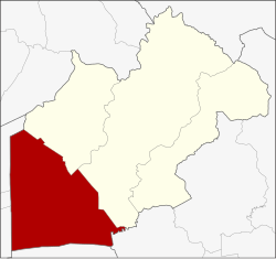
Amphoe Ongkharak
|
Ongkharak องครักษ์ |
|
|---|---|
| Province: | Nakhon Nayok |
| Surface: | 486.4 km² |
| Residents: | 61,817 (2013) |
| Population density : | 119.8 U / km² |
| ZIP : | 26120 |
| Geocode : | 2604 |
| map | |

|
|
Amphoe Ongkharak ( Thai อำเภอ องครักษ์ ) is a district ( Amphoe - Administrative District) in the western part of the Nakhon Nayok Province . The Nakhon Nayok Province is located in the north-eastern part of the central region of Thailand .
etymology
Ongkharak means royal guard . King Chulalongkorn (Rama V) once visited the Müang Nakhon Nayok. When he arrived in what is now Ongkharak, one of his royal guards fell ill and died shortly afterwards. The king ordered that a shrine be built in his honor to commemorate this incident.
geography
Neighboring districts (northeast-clockwise) the Amphoe Ban Na and Mueang Nakhon Nayok of Nakhon Nayok, Amphoe Ban Sang the province Prachin Buri , Amphoe Bang Nam Priao the province Chachoengsao , and Amphoe Lam Luk Ka , Thanyaburi and Nong Suea of Pathum Thani Province .
The main water resources of the district are the Mae Nam Nakhon Nayok ( Nakhon Nayok River ) and the Khlong Rangsit .
history
The old administrative building of Ongkharak County was initially located in Tambon Bang O (in today's Amphoe Ban Na ). King Chulalongkorn commissioned the construction of a canal ( Khlong ) in 1889 , which was to connect the Mae Nam Chao Phraya with the Nakhon Nayok River. The lock on the Chao Phraya was Chulalongkorn lock ( ประตูน้ำ จุฬาลงกรณ์ given), that at the other end of the channel Saovabha-Bhongsi-lock ( ประตูน้ำ เสาวภา ผ่อง ศรี ), the channel itself was Rangsit Canal . As a result, the district administration was relocated to the nearby 16th branch of the Khlong Rangsit. About 20 years later it was relocated again near the Saovabha Bhongsi Lock. Today the district administration is behind the Saovabha market, 500 meters from the old location.
education
The Ongkharak Campus of Srinakharinwirot University is located in this county.
administration
Provincial Administration
Ongkharak County is divided into eleven tambon ("subdistricts" or "parishes"), which are further subdivided into 116 muban ("villages").
| No. | Surname | Thai | Muban | Pop. |
|---|---|---|---|---|
| 1. | Phra Achan | พระ อาจารย์ | 13 | 6,432 |
| 2. | Bueng San | บึง ศาล | 9 | 5,585 |
| 3. | Sisa Krabue | ศีรษะกระบือ | 13 | 6,732 |
| 4th | Pho Thaen | โพธิ์ แทน | 9 | 4,507 |
| 5. | Bang Sombun | บาง สมบูรณ์ | 13 | 3,953 |
| 6th | Sai Mun | ทรายมูล | 11 | 5,312 |
| 7th | Bang Pla feces | บาง ปลา กด | 11 | 7,253 |
| 8th. | Bang Luk Suea | บาง ลูกเสือ | 12 | 3,633 |
| 9. | Ongkharak | องครักษ์ | 7th | 6,948 |
| 10. | Chumphon | ชุมพล | 8th | 5,409 |
| 11. | Khlong Yai | คลองใหญ่ | 10 | 6,053 |
Local administration
There is one municipality with "small town" status ( Thesaban Tambon ) in the district:
- Ongkharak (Thai: เทศบาล ตำบล องครักษ์ ) consisting of the parts of the tambon Sai Mun, Ongkharak.
In addition, there are eleven " tambon administration organizations " ( องค์การ บริหาร ส่วน ตำบล - Tambon Administrative Organizations, TAO)
- Phra Achan (Thai: องค์การ บริหาร ส่วน ตำบล พระ อาจารย์ ) consisting of the complete Tambon Phra Achan.
- Bueng San (Thai: องค์การ บริหาร ส่วน ตำบล บึง ศาล ) consisting of the complete Tambon Bueng San.
- Sisa Krabue (Thai: องค์การ บริหาร ส่วน ตำบล ศีรษะกระบือ ) consisting of the complete tambon Sisa Krabue.
- Pho Thaen (Thai: องค์การ บริหาร ส่วน ตำบล โพธิ์ แทน ) consisting of the complete Tambon Pho Thaen.
- Bang Sombun (Thai: องค์การ บริหาร ส่วน ตำบล บาง สมบูรณ์ ) consisting of the complete Tambon Bang Sombun.
- Sai Mun (Thai: องค์การ บริหาร ส่วน ตำบล ทรายมูล ) consisting of parts of the tambon Sai Mun.
- Bang Pla Kot (Thai: องค์การ บริหาร ส่วน ตำบล บาง ปลา กด ) consisting of the complete Tambon Bang Pla Kot.
- Bang Luk Suea (Thai: องค์การ บริหาร ส่วน ตำบล บาง ลูกเสือ ) consisting of the complete tambon Bang Luk Suea.
- Ongkharak (Thai: องค์การ บริหาร ส่วน ตำบล องครักษ์ ) consisting of parts of the Tambon Ongkharak.
- Chumphon (Thai: องค์การ บริหาร ส่วน ตำบล ชุมพล ) consisting of the complete tambon chumphon.
- Khlong Yai (Thai: องค์การ บริหาร ส่วน ตำบล คลองใหญ่ ) consisting of the complete tambon Khlong Yai.
Individual evidence
- ↑ 2013 population statistics ( Thai ) Department of Provincial Administration. Retrieved October 9, 2014.
Web links
- History of Ongkharak County (in Thai)
- More details on Amphoe Ongkharak from amphoe.com (in Thai)
Coordinates: 14 ° 7 ' N , 101 ° 0' E

