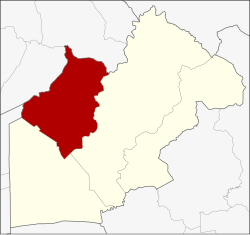
Amphoe Ban Na
|
Ban Na บ้านนา |
|
|---|---|
| Province: | Nakhon Nayok |
| Surface: | 388.4 km² |
| Residents: | 69,318 (2013) |
| Population density : | 173.2 U / km² |
| ZIP : | 26110 |
| Geocode : | 2603 |
| map | |

|
|
Amphoe Ban Na ( Thai : อำเภอ บ้านนา ) is a district ( amphoe - administrative district) in the western part of Nakhon Nayok Province . The Nakhon Nayok Province is located in the north-eastern part of the central region of Thailand .
geography
Neighboring districts (clockwise from east): Amphoe Mueang Nakhon Nayok and Ongkharak of Nakhon Nayok Province, Amphoe Nong Suea of Pathum Thani Province and Amphoe Wihan Daeng and Amphoe Kaeng Khoi of Saraburi Province .
The most important water resource in the county is the Khlong Ban Na.
history
During the Ayutthaya period, the inhabitants of a village in Tambon Pa Kha were elephant hunters ( กอง โพน ช้าง ) who captured wild elephants to train them to become war elephants.
Ban Na County was established in 1903 under the name Tha Chang (Elephant Pier) . Because the administration building in Tambon Bang O was in an inconvenient location for transportation and annual flooding, the government moved the building to Suwannason Road in 1965.
During a general reorganization in the early 20th century, Ban Na County was initially assigned to Saraburi Province , but on May 9, 1946 back to Nakhon Nayok.
military
The preparation school of the Thai armed forces is located in Amphoe Ban Na. It prepares boys between the ages of 15 and 18 for the officer schools of the army , navy , air force and police.
administration
Provincial Administration
The district of Ban Na is divided into ten tambon ("subdistricts" or "municipalities"), which are further subdivided into 116 muban ("villages").
| No. | Surname | Thai | Muban | Pop. |
|---|---|---|---|---|
| 1. | Ban Na | บ้านนา | 11 | 8,666 |
| 2. | Ban Phrao | บ้าน พร้าว | 12 | 5,194 |
| 3. | Ban Phrik | บ้าน พริก | 12 | 10,625 |
| 4th | Asa | อาษา | 8th | 2,483 |
| 5. | Thonglang | ทองหลาง | 8th | 5,199 |
| 6th | Bang O | บางอ้อ | 14th | 4,254 |
| 7th | Phikun Ok | พิกุล ออก | 12 | 5,687 |
| 8th. | Pa Kha | ป่า ขะ | 13 | 8,637 |
| 9. | Khao Phoem | เขา เพิ่ม | 16 | 8,273 |
| 10. | Si Ka-ang | ศรี กะ อา ง | 10 | 10,300 |
Local administration
There are two municipalities with "small town" status ( Thesaban Tambon ) in the district:
- Phikun Ok (Thai: เทศบาล ตำบล พิกุล ออก ) consisting of parts of the tambon Phikun Ok.
- Ban Na (Thai: เทศบาล ตำบล บ้านนา ) consisting of the parts of the Tambon Ban Na, Phikun Ok.
In addition, there are nine " tambon administration organizations " ( องค์การ บริหาร ส่วน ตำบล - Tambon Administrative Organizations, TAO)
- Ban Na (Thai: องค์การ บริหาร ส่วน ตำบล บ้านนา ) consisting of parts of the tambon Ban Na.
- Ban Phrao (Thai: องค์การ บริหาร ส่วน ตำบล บ้าน พร้าว ) consisting of the complete tambon Ban Phrao.
- Ban Phrik (Thai: องค์การ บริหาร ส่วน ตำบล บ้าน พริก ) consisting of the complete tambon Ban Phrik.
- Asa (Thai: องค์การ บริหาร ส่วน ตำบล อาษา ) consisting of the complete tambon Asa.
- Thonglang (Thai: องค์การ บริหาร ส่วน ตำบล ทองหลาง ) consisting of the complete tambon Thonglang.
- Bang O (Thai: องค์การ บริหาร ส่วน ตำบล บางอ้อ ) consisting of the complete tambon Bang O.
- Pa Kha (Thai: องค์การ บริหาร ส่วน ตำบล ป่า ขะ ) consisting of the complete tambon Pa Kha.
- Khao Phoem (Thai: องค์การ บริหารส่วน ตำบล เขา เพิ่ม ) consisting of the complete Tambon Khao Phoem.
- Si Ka-ang (Thai: องค์การ บริหาร ส่วน ตำบล ศรี กะ อา ง ) consisting of the complete tambon Si Ka-ang.
Individual evidence
- ↑ 2013 population statistics ( Thai ) Department of Provincial Administration. Retrieved October 9, 2014.
Web links
- History of Ban Na County (in Thai)
- More details on Ban Na from amphoe.com (in Thai)
Coordinates: 14 ° 16 ' N , 101 ° 4' E

