Thanyaburi district
|
Thanyaburi ธัญบุรี |
|
|---|---|
| Province: | Pathum Thani |
| Surface: | 112.124 km² |
| Residents: | 195,663 (2013) |
| Population density : | 1447 E./km² |
| ZIP : | 12110, 12130 |
| Geocode : | 1303 |
| map | |

|
|
Amphoe Thanyaburi ( Thai : อำเภอ ธัญบุรี , pronunciation: ʔāmpʰɤ̄ː tʰān.jáʔ.bū.rīː ) is a district ( Amphoe - administrative district) of the Pathum Thani Province in the central region of Thailand . The province is located directly north of Bangkok and is part of the Bangkok Metropolitan Region .
By far the largest city in the Thanyaburi district is Rangsit , while the administrative seat is the small town of Thanyaburi .
geography
Amphoe Thanyaburi has a very elongated shape. It extends over a length of about 35 kilometers and a width of 1.5 kilometers to the left and right of the Rangsit Canal and the parallel Rangsit – Nakhon Nayok road .
Thanyaburi is located in the eastern part of the lowlands of the Mae Nam Chao Phraya ( Chao Phraya River ), which was called Thung Luang here.
The main water resource of Thanyaburi is the Khlong Rangsit . It was the first canal ( Khlong ) in Siam that was built for irrigation purposes only.
Neighboring districts are (from north clockwise): Amphoe Khlong Luang and Nong Suea of Pathum Thani Province, Amphoe Ongkharak of Nakhon Nayok Province and Amphoe Lam Luk Ka and Mueang Pathum Thani turn in Pathum Thani.
economy
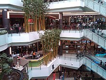
- Future Park Rangsit - opened on March 17, 1995, Future Park is said to be the largest shopping center in Asia, with around 70 restaurants, a post office, several cinemas and countless smaller retail stores in addition to the eight largest banks in Thailand. Branches of the most important department store chains in Thailand, such as Central, Robinson, Big C and TOPS can also be found here. Up to 150,000 people are said to come here to shop and relax at the weekend.
- The Dream World amusement park is also located in the Thanyaburi district .
traffic
The following important road connections run through the district:
- The Pahonyothin Expressway ( ถนน พหลโยธิน - Thanon Phahonyothin ), which as National Road 1 ( ทางหลวง แผ่นดิน หมายเลข 1 ) connects the capital Bangkok with northern Thailand and the northeast region of Thailand, the so-called Isan .
- The Outer Bangkok Ring Road (National Road 9, ทางหลวง พิเศษ หมายเลข 9 ), a freeway that serves as a large bypass for Bangkok.
- National Road 305 as the connection between National Road 1 and Nakhon Nayok .
history
Müang Thanyaburi was founded in 1901 at the behest of King Chulalongkorn (Rama V) . The name roughly means rice city . At the same time, King Chulalongkorn had Min Buri ( Fish City ) founded as a twin city. This was done as part of the development of the Rangsit area north of Bangkok. This gotthe most modern irrigation system in the countrythrough a project by the private Siam Land, Canals, and Irrigation Company in the 1890s. In the period that followed, land prices rose rapidly and there was a massive influx of farmers and workers.
education
- Rajamangala Thanyaburi Technical University
- University of Applied Sciences for Administration
- Eastern Asia University
- Institute of Physical Education Bangkok Campus
Sports
- Leo Stadium, home of Bangkok Glass FC
- Sports stadium to celebrate Queen Sirikit's 60th birthday
administration
Provincial Administration
Thanyaburi County is divided into six tambon ("subdistricts" or "parishes"), which are further subdivided into 28 muban ("villages").
| No. | Surname | Thai | Muban | Pop. |
|---|---|---|---|---|
| 1. | Prachathipat | ประชาธิปัตย์ | - | 78,942 |
| 2. | Bueng Yitho | บึง ยี่โถ | 4th | 31,028 |
| 3. | Rangsit | รังสิต | 4th | 22,408 |
| 4th | Lam Phak Kut | ลำ ผัก กูด | 4th | 35,261 |
| 5. | Bueng Sanan | บึง สนั่น | - | 10,537 |
| 6th | Bueng Nam Rak | บึง น้ำ รักษ์ | - | 17,487 |
Note: Some of the Muban's data are not yet available.
Local administration
There is one commune with "big city" status ( Thesaban Nakhon ) in the county:
- Rangsit ( เทศบาล นคร รังสิต ) consisting of the complete Tambon Prachathipat.
There are two municipalities with "city" status ( Thesaban Mueang ) in the district:
- Sanan Rak (Thai: เทศบาล เมือง สนั่น รักษ์ ) consisting of the complete tambon Bueng Sanan, Bueng Nam Rak.
- Bueng Yitho ( เทศบาล เมือง บึง ยี่โถ ) consisting of the complete tambon Bueng Yitho.
There is one municipality with "small town" status ( Thesaban Tambon ) in the district:
- Thanyaburi ( เทศบาล ตำบล ธัญบุรี ) consisting of the complete Tambon Rangsit and Lam Phak Kut.
Individual evidence
- ↑ 2013 population statistics ( Thai ) Department of Provincial Administration. Retrieved August 10, 2014.
Web links
- More information on Amphoe Thanyaburi from amphoe.com (in Thai). Archived from the original on May 21, 2010 ; accessed on July 27, 2015 .
- Future Park Rangsit website (in Thai and English)
Coordinates: 14 ° 1 ' N , 100 ° 44' E


