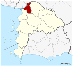
Phan Thong district
|
Phan Thong พานทอง |
|
|---|---|
| Province: | Chonburi |
| Surface: | 173.0 km² |
| Residents: | 58,157 (2013) |
| Population density : | 259 U / km² |
| ZIP : | 20160 |
| Geocode : | 2005 |
| map | |

|
|
Amphoe Phan Thong ( Thai : อำเภอ พานทอง ) is a district ( amphoe - administrative district) in Chonburi Province . The Chonburi Province is located in the east of the central region of Thailand .
geography
The neighboring counties are clockwise from the north: Bang Pakong and Ban Pho Amphoe (both located in Chachoengsao Province ) and Phanat Nikhom , Ban Bueng and Mueang Chonburi Area in Chonburi Province.
history
The upswing of Amphoe Phan Thong went hand in hand with increasing tourism on the Gulf of Thailand . Recently, however, companies in the electrical and chemical industries have also settled here, who want to escape the chronic traffic problems in Bangkok.
administration
Provincial Administration
Phan Thong County is divided into eleven tambon ("subdistricts" or "communities"), which are further subdivided into 76 muban ("villages").
| No. | Surname | Thai | Muban | Pop. |
|---|---|---|---|---|
| 1. | Phan Thong | พานทอง | 10 | 9,531 |
| 2. | Nong Tamlueng | หนอง ตำลึง | 9 | 9,999 |
| 3. | Map pong | มา บ โป่ง | 10 | 7,957 |
| 4th | Nong Kakha | หนอง กะ ขะ | 5 | 5,476 |
| 5. | Nong Hong | หนอง หง ษ์ | 6th | 5,801 |
| 6th | Khok Khi Non | โคก ขี้หนอน | 5 | 3,186 |
| 7th | Ban Kao | บ้าน เก่า | 7th | 3,540 |
| 8th. | Well Pradu | หน้า ประดู่ | 5 | 2,645 |
| 9. | Bang Nang | บาง นาง | 9 | 6,209 |
| 10. | Ko Loi | เกาะ ลอย | 6th | 2,610 |
| 11. | Bang Hak | บาง หัก | 4th | 1,203 |
Local administration
There are two municipalities with "small town" status ( Thesaban Tambon ) in the district:
- Phan Thong (Thai: เทศบาล ตำบล พานทอง ) consisting of parts of the Tambon Phan Thong.
- Nong Tamlueng (Thai: เทศบาล ตำบล หนอง ตำลึง ) consisting of the complete Tambon Nong Tamlueng and parts of the Tambon Map Pong, Nong Kakha.
In addition, there are eight " tambon administration organizations " ( องค์การ บริหาร ส่วน ตำบล - Tambon Administrative Organizations, TAO)
- Phan Thong (Thai: องค์การ บริหารส่วน ตำบล พานทอง ) consisting of the parts of the Tambon Phan Thong, Nong Kakha.
- Map Pong (Thai: องค์การ บริหาร ส่วน ตำบล มา บ โป่ง ) consisting of parts of the Tambon Map Pong.
- Nong Hong (Thai: องค์การ บริหาร ส่วน ตำบล หนอง หง ษ์ ) consisting of the complete Tambon Nong Hong.
- Khok Khi Non (Thai: องค์การ บริหาร ส่วน ตำบล โคก ขี้หนอน ) consisting of the complete tambon Khok Khi Non.
- Ban Kao (Thai: องค์การ บริหาร ส่วน ตำบล บ้าน เก่า ) consisting of the complete tambon Ban Kao.
- Na Pradu (Thai: องค์การ บริหาร ส่วน ตำบล หน้า ประดู่ ) consisting of the complete Tambon Na Pradu.
- Bang Nang (Thai: องค์การ บริหาร ส่วน ตำบล บาง นาง ) consisting of the complete Tambon Bang Nang.
- Ko Loi (Thai: องค์การ บริหาร ส่วน ตำบล เกาะ ลอย ) consisting of the complete Tambon Ko Loi, Bang Hak.
Individual evidence
- ↑ 2013 population statistics ( Thai ) Department of Provincial Administration. Retrieved October 9, 2014.
Web links
Coordinates: 13 ° 28 ' N , 101 ° 6' E