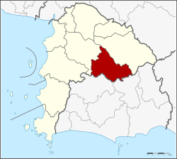
Nong Yai district
|
Nong Yai หนองใหญ่ |
|
|---|---|
| Province: | Chonburi |
| Surface: | 397.5 km² |
| Residents: | 23,109 (2013) |
| Population density : | 55.3 U / km² |
| ZIP : | 20190 |
| Geocode : | 2003 |
| map | |

|
|
Amphoe Nong Yai ( Thai : อำเภอ หนองใหญ่ ) is a district ( Amphoe - administrative district) in Chonburi Province . The Chonburi Province is located in the east of the central region of Thailand .
geography
Neighboring districts are made clockwise from the north: Amphoe Wang Chan and Amphoe Pluak Daeng of Rayong province and Amphoe Si Racha , Ban Bueng and Bo Thong Chonburi province.
history
The "Branch Circle" ( King Amphoe ) Nong Yai was established on December 1, 1975. On July 13, 1981, he was then raised to a complete district (Amphoe) .
administration
Provincial Administration
Nong Yai County is divided into five tambon ("subdistricts" or "parishes"), which are further subdivided into 23 muban ("villages").
| No. | Surname | Thai | Muban | Pop. |
|---|---|---|---|---|
| 1. | Nong Yai | หนองใหญ่ | 5 | 8,011 |
| 2. | Khlong Phlu | คลอง พลู | 4th | 3,901 |
| 3. | Nong Suea Chang | หนองเสือ ช้าง | 5 | 4.114 |
| 4th | Hang Sung | ห้าง สูง | 5 | 3,395 |
| 5. | Khao Sok | เขา ซ ก | 4th | 3,688 |
Local administration
There is one municipality with "small town" status ( Thesaban Tambon ) in the district:
- Nong Yai (Thai: เทศบาล ตำบล หนองใหญ่ ) consisting of the complete Tambon Nong Yai.
There are also four " tambon administration organizations " ( องค์การ บริหาร ส่วน ตำบล - Tambon Administrative Organizations, TAO)
- Khlong Phlu (Thai: องค์การ บริหาร ส่วน ตำบล คลอง พลู ) consisting of the complete tambon Khlong Phlu.
- Nong Suea Chang (Thai: องค์การ บริหาร ส่วน ตำบล หนองเสือ ช้าง ) consisting of the complete tambon Nong Suea Chang.
- Hang Sung (Thai: องค์การ บริหาร ส่วน ตำบล ห้าง สูง ) consisting of the complete tambon Hang Sung.
- Khao Sok (Thai: องค์การ บริหาร ส่วน ตำบล เขา ซ ก ) consisting of the complete tambon Khao Sok.
Individual evidence
- ↑ ประกาศ กระทรวง มหาดไทย เรื่อง แบ่ง ท้องที่ อำเภอ บ้านบึง จังหวัด ชลบุรี ตั้ง เป็น กิ่ง อำเภอ หนองใหญ่ - Royal Gazette, Vol. 92, Ed. 245 ง , December 1, 1975, p. 3062 (in Thai)
- ↑ พระราชกฤษฎีกา ตั้ง อำเภอ หนองใหญ่ อำเภอ บ่อไร่ อำเภอ พรหมคีรี อำเภอ นาบอน อำเภอ บางสะพาน น้อย อำเภอ นาดี อำเภอ กงหรา อำเภอ วังทรายพูน อำเภอ ธารโต อำเภอ คำตากล้า อำเภอ อำเภอ ศรีนคร อำเภอ ด่านช้าง อำเภอ พรเจริญ อำเภอ วังสามหมอ และ อำเภอ ลานสัก พ.ศ. ๒๕๒๔ - Royal Gazette, Vol. 98, Ed. 115 ก ฉบับ พิเศษ (special), from July 13, 1981, pp. 7-10 (in Thai)
- ↑ 2013 population statistics ( Thai ) Department of Provincial Administration. Retrieved October 9, 2014.
Web links
Coordinates: 13 ° 9 ′ N , 101 ° 22 ′ E