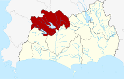
Pluak Daeng district
|
Pluak Daeng ปลวกแดง |
|
|---|---|
| Province: | Rayong |
| Surface: | 618.341 km² |
| Residents: | 58,258 (2015) |
| Population density : | 94.2 U / km² |
| ZIP : | 21140 |
| Geocode : | 2106 |
| map | |

|
|
Amphoe Pluak Daeng (in Thai : อำเภอ ปลวกแดง ) is a district ( Amphoe - administrative district) in the north-west of Rayong Province . Rayong Province is located in the east of the central region of Thailand .
etymology
The name of the district comes from the time it was founded. The residents found an anthill full of unusual red termites (Thai: Pluak Daeng - ปลวกแดง ).
geography
Neighboring districts (from the west in the clockwise) Amphoe Wang Chan , Ban Khai and Nikhom Patthana Rayong province and the Amphoe Bang Lamung , Si Racha and Nong Yai the Chonburi .
The main water resource is the Nong Pla Lai reservoir.
history
Originally this area belonged to the Ban Khai district . Pluak Daeng was established in 1970 as a “branch circle” ( King Amphoe ) , at that time consisting of the two Tambon Ta Sit and Pluak Daeng. On March 25, 1979, he received full amphoe status.
administration
Provincial Administration
Pluak Daeng County is divided into six tambon ("subdistricts" or "parishes"), which are further subdivided into 34 muban ("villages").
| No. | Surname | Thai | Muban | Pop. |
|---|---|---|---|---|
| 1. | Pluak Daeng | ปลวกแดง | 6th | 17,400 |
| 2. | Ta Sit | ตา สิทธิ์ | 4th | 7,622 |
| 3. | Lahan | ละ หาร | 4th | 4,960 |
| 4th | Maenam Khu | แม่น้ำ คู้ | 7th | 9,541 |
| 5. | Map Yang Phon | มา บ ยาง พร | 7th | 14,381 |
| 6th | Nong Rai | หนอง ไร่ | 6th | 4,354 |
Local administration
There are two municipalities with "small town" status ( Thesaban Tambon ) in the district:
- Chomphon Chao Phraya (Thai: เทศบาล ตำบล จอมพล เจ้าพระยา ) consisting of parts of the Tambon Ta Sit.
- Ban Pluak Daeng (Thai: เทศบาล ตำบล บ้าน ปลวกแดง ) consisting of parts of the Tambon Pluak Daeng.
In addition, there are six " tambon administration organizations " ( องค์การ บริหาร ส่วน ตำบล - Tambon Administrative Organizations, TAO)
- Pluak Daeng (Thai: องค์การ บริหาร ส่วน ตำบล ปลวกแดง ) consisting of parts of the tambon Pluak Daeng.
- Ta Sit (Thai: องค์การ บริหาร ส่วน ตำบล ตา สิทธิ์ ) consisting of parts of the Tambon Ta Sit.
- Lahan (Thai: องค์การ บริหาร ส่วน ตำบล ละ หาร ) consisting of the complete Tambon Lahan.
- Maenam Khu (Thai: องค์การ บริหาร ส่วน ตำบล แม่น้ำ คู้ ) consisting of the complete tambon Maenam Khu.
- Map Yang Phon (Thai: องค์การ บริหาร ส่วน ตำบล มา บ ยาง พร ) consisting of the complete Tambon Map Yang Phon.
- Nong Rai (Thai: องค์การ บริหาร ส่วน ตำบล หนอง ไร่ ) consisting of the complete Tambon Nong Rai.
Individual evidence
- ↑ ประกาศ กระทรวง มหาดไทย เรื่อง แบ่ง ท้องที่ ตั้ง เป็น กิ่ง อำเภอ กิ่ง อำเภอ ปลวกแดง จังหวัด ระยอง Royal Gazette, Vol. 87, Issue 47 ง special ( ฉบับ พิเศษ ) from June 1, 1970, p. 12 (in Thai)
- ↑ พระราชกฤษฎีกา ตั้ง อำเภอ หนองกุงศรี อำเภอ ไทรงาม อำเภอ บ้านฝาง อำเภอ อุบลรัตน์ อำเภอ เวียงชัย อำเภอ ดอยเต่า อำเภอ นิคมคำสร้อย อำเภอ นาหว้า อำเภอ เสิงสาง อำเภอ ศรีสาคร อำเภอ บึงสามพัน อำเภอ นาดูน อำเภอ อำเภอ ค้อวัง อำเภอ โพธิ์ชัย อำเภอ อำเภอ เมืองสรวง อำเภอ ปลวกแดง อำเภอ ยางชุมน้อย อำเภอ กาบเชิง อำเภอ สุวรรณคูหา และ อำเภอ กุดข้าวปุ้น พ.ศ. ๒๕๒๒ Royal Gazette, Vol. 96, Issue 42 ก special ( ฉบับ พิเศษ ) of March 25, 1979, pp. 19–24 (in Thai)
- ↑ 2015 population statistics ( Thai ) Department of Provincial Administration. Retrieved August 24, 2016.
Web links
Coordinates: 12 ° 58 ' N , 101 ° 13' E
