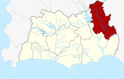
Amphoe Khao Chamao
|
Khao Chamao เขา ชะ เมา |
|
|---|---|
| Province: | Rayong |
| Surface: | 269.95 km² |
| Residents: | 23,775 (2013) |
| Population density : | 83.1 U / km² |
| ZIP : | 21110 |
| Geocode : | 2107 |
| map | |

|
|
Amphoe Khao Chamao (in Thai : อำเภอ เขา ชะ เมา ) is a district ( amphoe - administrative district) in the northeast of Rayong Province . Rayong Province is located in the east of the central region of Thailand .
geography
Neighboring districts (clockwise from north): Bo Thong district of Chonburi province , Kaeng Hang Maeo district of Chanthaburi province, and Klaeng and Wang Chan district of Rayong province.
The Khao Chamao - Khao Wong National Park is partly in the district.
history
The "branch circle" ( King Amphoe ) Khao Chamao was separated from the Amphoe Klaeng in 1993 . By a resolution of the Thai government on May 15, 2007, all 81 King Amphoe were raised to "normal" Amphoe status in order to simplify administration. With the publication in the Royal Gazette "Issue 124 chapter 46" on August 24, 2007 this decision officially entered into force.
Attractions
- Khao Chamao Khao Wong National Park - located in both Rayong Province and Chanthaburi Province with an area of 84 km².
administration
Provincial Administration
The county of Khao Chamao is divided into four tambon ("subdistricts" or "parishes"), which are further subdivided into 29 muban ("villages").
| No. | Surname | Thai | Muban | Pop. |
|---|---|---|---|---|
| 1. | Nam Pen | น้ำ เป็น | 7th | 6,842 |
| 2. | Huai Thap Mon | ห้วย ทับ มอญ | 8th | 8,231 |
| 3. | Cham Kho | ชำ ฆ้ อ | 9 | 6.005 |
| 4th | Khao Noi | เขา น้อย | 5 | 2,697 |
Local administration
There is one municipality with "small town" status ( Thesaban Tambon ) in the district:
- Cham Kho (Thai: เทศบาล ตำบล ชำ ฆ้ อ ) consisting of the complete Tambon Cham Kho.
There are also three " tambon administration organizations " ( องค์การ บริหาร ส่วน ตำบล - Tambon Administrative Organizations, TAO)
- Nam Pen (Thai: องค์การ บริหาร ส่วน ตำบล น้ำ เป็น ) consisting of the complete Tambon Nam Pen.
- Khao Chamao (Thai: องค์การ บริหาร ส่วน ตำบล เขา ชะ เมา ) consisting of the complete Tambon Huai Thap Mon.
- Khao Noi (Thai: องค์การ บริหาร ส่วน ตำบล เขา น้อย ) consisting of the complete Tambon Khao Noi.
Individual evidence
- ↑ www.manager.co.th
- ↑ Royal Gazette, Vol. 124, Issue 46 ก, pp. 14–21 of August 24, 2007 ( พระราชกฤษฎีกา ตั้ง อำเภอ ฆ้องชัย ... และ อำเภอ เหล่า เสือ โก้ ก พ.ศ. ๒๕๕๐ - in Thai)
- ↑ 2013 population statistics ( Thai ) Department of Provincial Administration. Retrieved October 9, 2014.
Web links
- More details on Amphoe Khao Chamao from amphoe.com (in Thai)
- Information on the Khao Chamao National Park - Khao Wong (in English)
Coordinates: 12 ° 59 ' N , 101 ° 41' E
