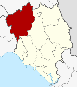
Kaeng Hang Maeo district
|
Kaeng Hang Maeo แก่ง หาง แมว |
|
|---|---|
| Province: | Chanthaburi |
| Surface: | 1,254.1 km² |
| Residents: | 40,935 (2013) |
| Population density : | 29.1 U / km² |
| ZIP : | 22160 |
| Geocode : | 2208 |
| map | |

|
|
Amphoe Kaeng Hang Maeo ( Thai : อำเภอ แก่ง หาง แมว ) is a district ( amphoe - administrative district) in the northwest of Chanthaburi Province . The Chanthaburi Province is located in the east of the central region of Thailand .
geography
Neighboring districts are clockwise from the east the Amphoe Soi Dao , Khao Khitchakut , Tha Mai and Na Yai Am Chantaburi province, Amphoe Klaeng and Amphoe Khao Chamao the province of Rayong , Amphoe Bo Thong of Chonburi Province , Amphoe Tha Takiap of Chachoengsao Province and Wang Sombun District of Sa Kaeo Province .
history
Kaeng Hang Maeo was initially set up as a "branch circle" ( King Amphoe ) on April 1, 1990 , by separating five tambon from Amphoe Tha Mai . On September 8, 1992, Kaeng Hang Maeo was given full amphoe status.
administration
Provincial Administration
Kaeng Hang Maeo County is divided into five tambon ("subdistricts" or "parishes"), which are further subdivided into 66 muban ("villages").
| No. | Surname | Thai | Muban | Pop. |
|---|---|---|---|---|
| 1. | Kaeng Hang Maeo | แก่ง หาง แมว | 22nd | 9,688 |
| 2. | Khun Song | ขุน ซ่อง | 18th | 11,725 |
| 3. | Sam Phi Nong | สามพี่น้อง | 10 | 5,955 |
| 4th | Phawa | พ วา | 12 | 10,492 |
| 5. | Khao Wongkot | เขา วงกต | 4th | 3,075 |
Local administration
There is one municipality with "small town" status ( Thesaban Tambon ) in the district:
- Phawa (Thai: เทศบาล ตำบล พ วา ) consisting of the complete Tambon Phawa.
There are also four " tambon administration organizations " ( องค์การ บริหาร ส่วน ตำบล - Tambon Administrative Organizations, TAO)
- Kaeng Hang Maeo (Thai: องค์การ บริหาร ส่วน ตำบล แก่ง หาง แมว ) consisting of the complete tambon Kaeng Hang Maeo.
- Khun Song (Thai: องค์การ บริหาร ส่วน ตำบล ขุน ซ่อง ) consisting of the complete Tambon Khun Song.
- Sam Phi Nong (Thai: องค์การ บริหาร ส่วน ตำบล สามพี่น้อง ) consisting of the complete Tambon Sam Phi Nong.
- Khao Wongkot (Thai: องค์การ บริหารส่วน ตำบล เขา วงกต ) consisting of the complete tambon Khao Wongkot.
Individual evidence
- ↑ ประกาศ กระทรวง มหาดไทย เรื่อง แบ่ง เขต ท้องที่ อำเภอ ท่าใหม่ จังหวัด จันทบุรี ตั้ง เป็น กิ่ง อำเภอ แกง หาง แมว Royal Gazette, Vol. 107, Issue 25 ง of February 13, 1990, p. 1348 (in Thai)
- ↑ พระราชกฤษฎีกา ตั้ง อำเภอ ด่าน มะขาม เตี้ย อำเภอ แก่ง หาง แมว อำเภอ ภักดี ชุมพล อำเภอ เวียง แก่น อำเภอ แม่ วาง อำเภอ ถ้ำ พรรณ รา อำเภอ บ่อ เกลือ อำเภอ อำเภอ โนน สุวรรณ อำเภอ ห้วย ราช อำเภอ แม่ ลาน อำเภอ บางแก้ว อำเภอ ป่า พะยอม อำเภอ หนอง ม่วง ไข่ สุ ราช สี สี สี สี สี สี สี อำเภอ จัง หาร อำเภอ บ้าน ธิ อำเภอ ภู สิงห์ อำเภอ บาง กล่ำ อำเภอ วัง ม่วง และ อำเภอ นา ยูง พ.ศ. ๒๕๓๘ Royal Gazette, Vol. 112, Issue 32 ก August 8, 1995, pp. 1–3 (in Thai)
- ↑ 2013 population statistics ( Thai ) Department of Provincial Administration. Retrieved October 8, 2014.
Web links
Coordinates: 13 ° 0 ' N , 101 ° 54' E
