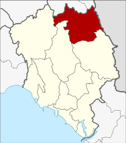
Soi Dao district
|
Soi Dao สอยดาว |
|
|---|---|
| Province: | Chanthaburi |
| Surface: | 733.8 km² |
| Residents: | 64,614 (2013) |
| Population density : | 85.0 U / km² |
| ZIP : | 22180 |
| Geocode : | 2207 |
| map | |

|
|
Amphoe Soi Dao ( Thai : อำเภอ สอยดาว ) is a district ( Amphoe - administrative district) in the north of Chanthaburi Province . The Chanthaburi Province is located in the east of the central region of Thailand .
geography
Neighboring districts are made clockwise from the South: Amphoe Pong Nam Ron , Khao Khitchakut and Kaeng Hang Maeo Chantaburi province, as well as the Amphoe Wang Sombun and Khlong Hat the province of Sa Kaeo . To the east lies the Battambang Province of Cambodia .
history
Amphoe Soi Dao was initially set up as a “branch circle” ( King Amphoe ) on January 1, 1988 by separating five tambon from Pong Nam Ron . Soi Dao was granted full amphoe status on May 9, 1992 .
Attractions
In the district is the Khao Soi Dao wildlife sanctuary ( สัตว์ ป่า, สอยดาว ), a 745 km² park with 85% rainforest. The most famous attraction in it is the Khao Soi Dao waterfall ( น้ำตก เขา สอยดาว ).
administration
Provincial Administration
Soi Dao County is divided into five tambon ("subdistricts" or "communities"), which are further subdivided into 70 muban ("villages").
| No. | Surname | Thai | Muban | Pop. |
|---|---|---|---|---|
| 1. | Pa Tong | ปะ ต ง | 11 | 15,393 |
| 2. | Thung Khanan | ทุ่ง ขนาน | 16 | 10,692 |
| 3. | Thap Chang | ทับ ช้าง | 18th | 16,123 |
| 4th | Sai Khao | ทรายขาว | 13 | 13.096 |
| 5. | Saton | สะ ตอน | 12 | 9,310 |
Local administration
There are two municipalities with "small town" status ( Thesaban Tambon ) in the district:
- Sai Khao (Thai: เทศบาล ตำบล ทรายขาว ) consisting of the parts of the Tambon Pa Tong, Sai Khao.
- Thap Chang (Thai: เทศบาล ตำบล ทับ ช้าง ) consisting of the complete tambon Thap Chang.
There are also four " tambon administration organizations " ( องค์การ บริหาร ส่วน ตำบล - Tambon Administrative Organizations, TAO)
- Pa Tong (Thai: องค์การ บริหาร ส่วน ตำบล ปะ ต ง ) consisting of parts of the Tambon Pa Tong.
- Thung Khanan (Thai: องค์การ บริหาร ส่วน ตำบล ทุ่ง ขนาน ) consisting of the complete tambon Thung Khanan.
- Sai Khao (Thai: องค์การ บริหาร ส่วน ตำบล ทรายขาว ) consisting of parts of the tambon Sai Khao.
- Saton (Thai: องค์การ บริหาร ส่วน ตำบล สะ ตอน ) consisting of the complete tambon Saton.
Individual evidence
- ↑ ประกาศ กระทรวง มหาดไทย เรื่อง แบ่ง เขต ท้องที่ อำเภอ โป่งน้ำร้อน จังหวัด จันทบุรี ตั้ง เป็น กิ่ง อำเภอ สอยดาว . In: Royal Gazette . 105, No. 5 ง , January 7 1988, p. 105.
- ↑ พระราชกฤษฎีกา ตั้ง อำเภอ สอยดาว อำเภอ โพน สวรรค์ อำเภอ บาง ขัน อำเภอ หว้า น ใหญ่ อำเภอ เมือง ปาน อำเภอ ภู หลวง อำเภอ โคก ศรีสุพรรณ และ อำเภอ สำโรง พ.ศ. ๒๕๓๕ . In: Royal Gazette . 109, No. 45 ก , April 9 1992, pp. 27-29.
- ↑ 2013 population statistics ( Thai ) Department of Provincial Administration. Retrieved October 8, 2014.
Web links
Coordinates: 13 ° 8 ' N , 102 ° 13' E
