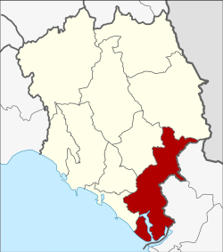
Amphoe cooling
|
Cooling ขลุง |
|
|---|---|
| Province: | Chanthaburi |
| Surface: | 756.038 km² |
| Residents: | 56,560 (2013) |
| Population density : | 72.8 U / km² |
| ZIP : | 22110, 22150 |
| Geocode : | 2202 |
| map | |

|
|
Amphoe Khlung ( Thai : อำเภอ ขลุง ) is the southernmost district ( Amphoe - administrative district) of Chanthaburi Province . The Chanthaburi Province is located in the east of the central region of Thailand .
geography
Neighboring Amphoe (clockwise from northwest): Laem Sing , Mueang Chanthaburi , Makham and Pong Nam Ron in Chanthaburi Province, Bo Rai , Khao Saming and Laem Ngop in Trat Province . In the southeast lies the Gulf of Thailand .
administration
Provincial Administration
The district of Khlung is divided into twelve tambon ("sub-districts" or "communities"), which are further subdivided into 90 muban ("villages").
| No. | Surname | Thai | Muban | Pop. |
|---|---|---|---|---|
| 1. | Cooling | ขลุง | - | 11,149 |
| 2. | Bo | บ่อ | 10 | 7,081 |
| 3. | Kwian Hak | เกวียน หัก | 10 | 4,606 |
| 4th | Tapon | ตะ ปอน | 6th | 3,221 |
| 5. | Bang chan | บางชัน | 6th | 3,508 |
| 6th | Wan Yao | วัน ยาว | 8th | 5,479 |
| 7th | Sueng | ซึ้ง | 11 | 5,009 |
| 8th. | Map Phai | มา บ ไพ | 6th | 2,476 |
| 9. | Wang Sappharot | วัง สรรพ รส | 9 | 3.137 |
| 10. | Trok Nong | ตรอก น อง | 6th | 2,489 |
| 11. | Tok Phrom | ตก พรม | 11 | 4,078 |
| 12. | Bo Welu | บ่อ เวฬุ | 7th | 4,327 |
Local administration
There is one commune with "city" status ( Thesaban Mueang ) in the district:
- Khlung (Thai: เทศบาล เมือง ขลุง ) consisting of the complete Tambon Khlung.
There are six municipalities with "small town" status ( Thesaban Tambon ) in the district:
- Wan Yao (Thai: เทศบาล ตำบล วัน ยาว ) consisting of the complete tambon Wan Yao.
- Sueng (Thai: เทศบาล ตำบล ซึ้ง ) consisting of the complete Tambon Sueng.
- Bo Welu (Thai: เทศบาล ตำบล บ่อ เวฬุ ) consisting of the complete tambon Bo Welu.
- Bo (Thai: เทศบาล ตำบล บ่อ ) consisting of the complete Tambon Bo.
- Kwian Hak (Thai: เทศบาล ตำบล เกวียน หัก ) consisting of the complete tambon Kwian Hak.
- Tok Phrom (Thai: เทศบาล ตำบล ตก พรม ) consisting of the complete tambon Tok Phrom.
There are also five " tambon administration organizations " ( องค์การ บริหาร ส่วน ตำบล - Tambon Administrative Organizations, TAO)
- Tapon (Thai: องค์การ บริหารส่วน ตำบล ตะ ปอน ) consisting of the complete tambon tapon.
- Bang Chan (Thai: องค์การ บริหาร ส่วน ตำบล บางชัน ) consisting of the complete Tambon Bang Chan.
- Map Phai (Thai: องค์การ บริหาร ส่วน ตำบล มา บ ไพ ) consisting of the complete Tambon Map Phai.
- Wang Sappharot (Thai: องค์การ บริหาร ส่วน ตำบล วัง สรรพ รส ) consisting of the complete tambon Wang Sappharot.
- Trok Nong (Thai: องค์การ บริหาร ส่วน ตำบล ตรอก น อง ) consisting of the complete tambon Trok Nong.
Individual evidence
- ↑ 2013 population statistics ( Thai ) Department of Provincial Administration. Retrieved October 8, 2014.
Web links
Coordinates: 12 ° 27 ' N , 102 ° 13' E
