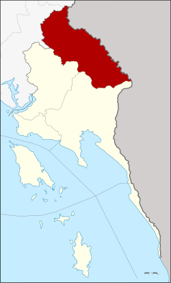
Bo Rai district
|
Bo Rai บ่อไร่ |
|
|---|---|
| Province: | Stepped |
| Surface: | 680.02 km² |
| Residents: | 35,186 (2013) |
| Population density : | 52 U / km² |
| ZIP : | 23140, 23160 |
| Geocode : | 2304 |
| map | |

|
|

Amphoe Bo Rai ( Thai : อำเภอ บ่อไร่ ) is a district ( Amphoe - administrative district) in the southeast of Trat Province . The Trat Province is located in the eastern region of Thailand on the border with Cambodia , but is administratively counted to central Thailand .
geography
The district is located in the north of the province.
Neighboring districts (clockwise from the south): Amphoe Mueang Trat and Khao Saming in Trat Province, Amphoe Khlung and Pong Nam Ron in Chanthaburi Province, and Battambang Province in Cambodia .
history
The area was once famous for the gemstones found here, such as rubies and sapphires . The trade in the precious stones made Bo Rai a prosperous town. From the 1960s to the 1990s, the city experienced an economic boom that ended almost overnight when the finds dried up. The subsequent economic depression was exacerbated by the disempowerment of the Khmer Rouge , as border trade in goods and precious stones came to a standstill. After 1979 there was a camp in Bo Rai for supporters of the Khmer Rouge who had fled Cambodia. Pol Pot also lived here from 1985 .
economy
After Bo Rai almost became a ghost town at the end of the last century, there have so far only been half-hearted attempts to support the economy, for example the construction of rubber plantations . Rumor has it that the Thai-Cambodian border will also be reopened to trade.
Attractions
- Namtok Khlong Kaeo National Park (Thai: อุทยานแห่งชาติ น้ำตก คลอง แก้ว ) - about nine kilometers from the town of Bo Rai with a waterfall that gave the park its name.
administration
Provincial Administration
Bo Rai County is divided into five tambon ("subdistricts" or "parishes"), which are further subdivided into 33 muban ("villages").
| No. | Surname | Thai | Muban | Pop. |
|---|---|---|---|---|
| 1. | Bo Phloi | บ่อพลอย | 10 | 15,426 |
| 2. | Chang Thun | ช้าง ทูน | 6th | 2,981 |
| 3. | Dan Chumphon | ด่าน ชุมพล | 7th | 5,205 |
| 4th | Nong Bon | หนอง บอน | 5 | 7,761 |
| 5. | Nonsi | นนทรี ย์ | 5 | 3.813 |
Local administration
There are two municipalities with "small town" status ( Thesaban Tambon ) in the district:
- Bo Phloi (Thai: เทศบาล ตำบล บ่อพลอย ) consisting of parts of the Tambon Bo Phloi.
- Nong Bon (Thai: เทศบาล ตำบล หนอง บอน ) consisting of the complete Tambon Nong Bon.
There are also four " tambon administration organizations " ( องค์การ บริหาร ส่วน ตำบล - Tambon Administrative Organizations, TAO)
- Bo Phloi (Thai: องค์การ บริหาร ส่วน ตำบล บ่อพลอย ) consisting of parts of the Tambon Bo Phloi.
- Chang Thun (Thai: องค์การ บริหาร ส่วน ตำบล ช้าง ทูน ) consisting of the complete Tambon Chang Thun.
- Dan Chumphon (Thai: องค์การ บริหาร ส่วน ตำบล ด่าน ชุมพล ) consisting of the complete tambon Dan Chumphon.
- Nonsi (Thai: องค์การ บริหาร ส่วน ตำบล นนทรี ย์ ) consisting of the complete Tambon Nonsi.
Individual evidence
- ↑ Information on Trat Province from the provincial administration (350kb WinWord file; in Thai)
- ^ Kelvin Rowley: Second Life, Second Death. The Khmer Rouge After 1978. Yale University Genocide Studies Program (GSP) Working Paper No. 24, 2004, p. 207.
- ↑ 2013 population statistics ( Thai ) Department of Provincial Administration. Retrieved October 24, 2014.
Web links
- More information about Amphoe Bo Rai from amphoe.com (in Thai)
- Information about the Namtok Khlong Kaeo National Park (in English)
Coordinates: 12 ° 35 ' N , 102 ° 32' E

