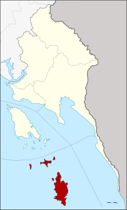
Amphoe Ko Kut
|
Ko Kut เกาะ กูด |
|
|---|---|
| Province: | Stepped |
| Surface: | 154.8 km² |
| Residents: | 2,464 (2013) |
| Population density : | 13.1 U / km² |
| ZIP : | 23000, 23120 |
| Geocode : | 2306 |
| map | |

|
|
Amphoe Ko Kut ( Thai : อำเภอ เกาะ กูด , pronunciation: ʔāmpʰɤ̄ː kɔ̀ʔ kùːt ) is a district ( amphoe - administrative district) in the south of the province of Trat . The Trat Province is located in the eastern region of Thailand on the border with Cambodia , but is administratively counted to central Thailand .
Ko Kut (other spelling: Ko Kood or Koh Kuut ) is also the name of the main island in the district in the Gulf of Thailand , south of Ko Chang . The district also includes the islands of Ko Mak , Ko Rang, Ko Kradat, Ko Mai Si and smaller secondary islands such as Ko Kham and others.
Demographics
Around 2,000 people live on the wooded, slightly hilly island (highest elevation 315 m). Ko Kut is the least densely populated district in Thailand.
history
In the past, today's district was part of the sub-district ( tambon ) Ko Chang in the district ( Amphoe ) Laem Ngop . When the Ko Mak sub-district was established in 1952, it comprised the entire island of Mak, which at that time consisted of four villages ( Muban ) . In 1980, three villages were separated from Ko Mak, and the sub-district Ko Kut was established.
On April 1, 1990, Tambon Ko Kut was promoted to "Branch Circle" ( King Amphoe ) together with Tambon Ko Mak .
On May 15, 2007 the Thai government decided to raise all 81 King Amphoe to simple amphoe status in order to unify the administration. With the publication in the Royal Gazette “Issue 124 chapter 46” on August 24, 2007 Ko Kut officially received full amphoe status.
administration
Provincial Administration
The district of Ko Kut is divided into two tambon ("sub-districts" or "municipalities"), which are further subdivided into eight muban ("villages").
| No. | Surname | Thai | Muban | Pop. |
|---|---|---|---|---|
| 1. | Ko Mak | เกาะ หมาก | 2 | 570 |
| 2. | Ko Kut | เกาะ กูด | 6th | 1,894 |
Local administration
In the district there are two " tambon administration organizations " ( องค์การ บริหาร ส่วน ตำบล - Tambon Administrative Organizations, TAO)
- Ko Mak (Thai: องค์การ บริหาร ส่วน ตำบล เกาะ หมาก ) consisting of the complete tambon Ko Mak.
- Ko Kut (Thai: องค์การ บริหาร ส่วน ตำบล เกาะ กูด ) consisting of the complete tambon Ko Kut.
Web links
Individual evidence
- ↑ Information on Trat Province from the provincial administration (350kb WinWord file; in Thai)
- ↑ ประกาศ กระทรวง มหาดไทย เรื่อง ตั้ง และ เปลี่ยนแปลง เขต ตำบล ใน ท้องที่ อำเภอ แหลมงอบ จังหวัด ตราด . In: Royal Gazette . 69, No. 43 ง , July 8, 1952, pp. 2008–2009.
- ↑ ประกาศ กระทรวง มหาดไทย เรื่อง ตั้ง และ เปลี่ยนแปลง เขต ตำบล ใน ท้องที่ อำเภอ แหลมงอบ จังหวัด ตราด . In: Royal Gazette . 97, No. 150 ง , September 30, 1980, p. 3391.
- ↑ ประกาศ กระทรวง มหาดไทย เรื่อง แบ่ง เขต ท้องที่ อำเภอ แหลมงอบ จังหวัด ตราด ตั้ง เป็น กิ่ง อำเภอ เกาะ กูด Royal Gazette Vol . 109, ed. 25 ง of February 13, 1990, p. 1351 (in Thai)
- ↑ www.manager.co.th
- ↑ พระราชกฤษฎีกา ตั้ง อำเภอ ฆ้องชัย ... และ อำเภอ เหล่า เสือ โก้ ก พ.ศ. ๒๕๕๐ Royal Gazette, Vol. 124, Issue 46 ก , pp. 14-21 of August 24, 2007 (in Thai)
- ↑ 2013 population statistics ( Thai ) Department of Provincial Administration. Retrieved October 24, 2014.
Coordinates: 11 ° 39 ' N , 102 ° 33' E
