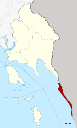
Khlong Yai district
|
Khlong Yai คลองใหญ่ |
|
|---|---|
| Province: | Stepped |
| Surface: | 50.29 km² |
| Residents: | 22,875 (2013) |
| Population density : | 482 U / km² |
| ZIP : | 23110 |
| Geocode : | 2302 |
| map | |

|
|
Amphoe Khlong Yai ( Thai : อำเภอ คลองใหญ่ ) is a district ( Amphoe - administrative district) in the southeast of the Trat Province . The Trat Province is located in the eastern region of Thailand on the border with Cambodia , but is administratively counted to central Thailand .
geography
The district is located in the southeast of the province. It consists of a narrow strip of land along the coast to the Gulf of Thailand , separated from Cambodia by the Cardamom Mountains .
Neighboring districts (clockwise from north): Amphoe Mueang Trat in Trat Province, Koh Kong Province in Cambodia and the Gulf of Thailand .
history
In the past, the area was part of the Patchanta Khiri Khet province (now Koh Kong ). Unlike other parts of Koh Kong, this stretch of land was given to Siam by the Franco-Siamese treaty during the reign of King Chulalongkorn (Rama V) in exchange for areas east of the Mekong and provinces in west Cambodia such as Battambang, Siam Nakhon and Sisophon .
In 1912, Khlong Yai was initially set up as a “branch circle” ( King Amphoe ) , and in 1959 it was upgraded to a complete amphoe.
administration
Provincial Administration
Khlong Yai County is divided into three tambon ("subdistricts" or "parishes"), which are further subdivided into 20 muban ("villages").
| No. | Surname | Thai | Muban | Pop. |
|---|---|---|---|---|
| 1. | Khlong Yai | คลองใหญ่ | 9 | 13,224 |
| 2. | May Ruth | ไม้ รูด | 6th | 4,745 |
| 3. | Has Lek | หาด เล็ก | 5 | 4,906 |
Local administration
There are two municipalities with "small town" status ( Thesaban Tambon ) in the district:
- Khlong Yai (Thai: เทศบาล ตำบล คลองใหญ่ ) consisting of parts of the Tambon Khlong Yai.
- Hat Lek (Thai: เทศบาล ตำบล หาด เล็ก ) consisting of the complete tambon Hat Lek.
There are also two " tambon administration organizations " ( องค์การ บริหาร ส่วน ตำบล - Tambon Administrative Organizations, TAO)
- Khlong Yai (Thai: องค์การ บริหาร ส่วน ตำบล คลองใหญ่ ) consisting of parts of the Tambon Khlong Yai.
- Mai Rut (Thai: องค์การ บริหาร ส่วน ตำบล ไม้ รูด ) consisting of the complete Tambon Mai Rut.
Individual evidence
- ↑ Information on Trat Province from the provincial administration (350kb WinWord file; in Thai)
- ↑ 2013 population statistics ( Thai ) Department of Provincial Administration. Retrieved October 23, 2014.
Web links
Coordinates: 11 ° 47 ' N , 102 ° 53' E