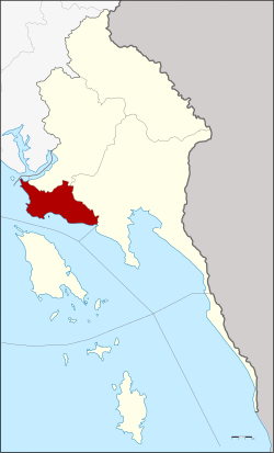
Amphoe Laem Ngop
|
Laem Ngop แหลมงอบ |
|
|---|---|
| Province: | Stepped |
| Surface: | 154.0 km² |
| Residents: | 19,276 (2013) |
| Population density : | 120 U / km² |
| ZIP : | 23120 |
| Geocode : | 2305 |
| map | |

|
|
Amphoe Laem Ngop ( Thai : อำเภอ แหลมงอบ ) is a district ( Amphoe - administrative district) in the west of the Trat Province . The Trat Province is located in the eastern region of Thailand on the border with Cambodia , but is administratively counted to central Thailand .
geography
Neighboring districts (clockwise from north): Amphoe Khlung in Chanthaburi Province and Amphoe Khao Saming and Mueang Trat in Trat Province. In the south lies the Gulf of Thailand .
history
Today's Laem Ngop County was initially set up as Ko Chang District in 1897. The administration building was in Ban Dan Kao on Ko Chang . The district controlled all of the islands in Trat Province. The location of the administration on an island was inconvenient for many residents of the mainland, so the government moved the administration building to Ban Laem Ngop, but kept the name. Later in 1939 the name of the district was renamed according to the location of the administration.
administration
Provincial Administration
Laem Ngop County is divided into four tambon (“subdistricts” or “parishes”), which are further subdivided into 27 muban (“villages”).
| No. | Surname | Thai | Muban | Pop. |
|---|---|---|---|---|
| 1. | Laem Ngop | แหลมงอบ | 7th | 5,558 |
| 2. | Nam Chiao | น้ำ เชี่ยว | 4th | 3,483 |
| 3. | Bang pit | บาง ปิด | 8th | 4,555 |
| 7th | Khlong Yai | คลองใหญ่ | 8th | 5,680 |
Local administration
There are two municipalities with "small town" status ( Thesaban Tambon ) in the district:
- Nam Chiao (Thai: เทศบาล ตำบล น้ำ เชี่ยว ) consisting of the complete Tambon Nam Chiao.
- Laem Ngop (Thai: เทศบาล ตำบล แหลมงอบ ) consisting of parts of the tambon Laem Ngop.
There are also three " tambon administration organizations " ( องค์การ บริหาร ส่วน ตำบล - Tambon Administrative Organizations, TAO)
- Laem Ngop (Thai: องค์การ บริหาร ส่วน ตำบล แหลมงอบ ) consisting of parts of the tambon Laem Ngop.
- Bang Pit (Thai: องค์การ บริหาร ส่วน ตำบล บาง ปิด ) consisting of the complete Tambon Bang Pit.
- Khlong Yai (Thai: องค์การ บริหาร ส่วน ตำบล คลองใหญ่ ) consisting of the complete tambon Khlong Yai.
Individual evidence
- ↑ Information on Trat Province from the provincial administration (350kb WinWord file; in Thai)
- ↑ พระราชกฤษฎีกา เปลี่ยน นาม อำเภอ กิ่ง อำเภอ และ ตำบล บาง แห่ง พุทธศักราช ๒๔๘๒ . In: Royal Gazette . 56, No. 0 ก , April 17 1939, pp. 354-364.
- ↑ 2013 population statistics ( Thai ) Department of Provincial Administration. Retrieved October 24, 2014.
Web links
Coordinates: 12 ° 10 ' N , 102 ° 24' E