
Ko Chang
| Ko Chang | ||
|---|---|---|
 |
||
| Waters | Gulf of Thailand | |
| Geographical location | 12 ° 3 ' N , 102 ° 19' E | |
|
||
| length | 30 km | |
| width | 13 km | |
| surface | 429 km² | |
| Highest elevation | Khao Salak Phet 744 m |
|
| Residents | 5356 (2005) 12 inhabitants / km² |
|
| main place | White sand beach | |
 |
||

Ko Chang (other spelling: Koh Chang , Thai : เกาะ ช้าง , pronunciation: [ kɔ̀ʔ tɕʰáːŋ ]) is an island in the province ( Changwat ) Trat in the eastern region of central Thailand . Ko Chang is also a small town in Ko Chang County ( Amphoe ) in Trat Province. The distance to the capital Bangkok is about 315 km .
Ko Chang literally means "elephant island", which is due to the natural shape of the island.
geography
Ko Chang is located in the Gulf of Thailand on the east coast of Thailand near the border with Cambodia . With 429 km² it is the second largest island in Thailand after Ko Phuket (492 km²).
The island is about 30 kilometers long and a maximum of 13 kilometers wide. Highest elevation: 744 m. ü. M., "Khao Salak Phet"
climate
Ko Chang has a tropical - monsoonal climate with three seasons:
- Cool season (November - February)
- Warm season (March - May)
- Rainy season (June - October)
The average temperatures are between 20 ° C and 33 ° C. The amount of precipitation is 2600 mm to 4000 mm.
tourism
The island, which is more remote from the major Thai resorts, is increasingly being developed for tourism. White sandy beaches, coral reefs for diving and sights such as waterfalls are attractions for vacationers.
There is no airport on the island, car ferries run regularly to the mainland. The nearest airport is Trat Airport .
photos

Khlong Phrao (Thai: หาด คลอง พร้าว - Hat Khlong Phrao)

White Sand Beach (Thai: หาด ทรายขาว - Hat Sai Khao)
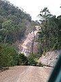
Ring road in the southeast


literature
- Schmidt, Johannes (1877-1933); Vegetation types from the island of Koh Chang in the Gulf of Siam, 1906 ; Jena (Gustav Fischer Vlg.)
See also
Web links
- German information from the Tourist Authority of Thailand (TAT)
- Information, pictures and 360 ° panoramas about Koh Chang (German)
- Information about getting to Koh Chang (German, 2017)
- Beaches and sights on Koh Chang (German, 2019)
Individual evidence
- ↑ UNEP islands (English)