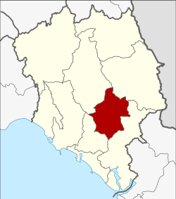
Makham district
|
Makham มะขาม |
|
|---|---|
| Province: | Chanthaburi |
| Surface: | 480.1 km² |
| Residents: | 31,195 (2013) |
| Population density : | 61.4 U / km² |
| ZIP : | 22150 |
| Geocode : | 2205 |
| map | |

|
|
Amphoe Makham ( Thai อำเภอ มะขาม ) is a district ( Amphoe - administrative district) in Chanthaburi Province . The Chanthaburi Province is located in the east of the central region of Thailand .
geography
Neighboring Amphoe (clockwise from southwest): the Mueang Chanthaburi , Khao Khitchakut , Pong Nam Ron and Khlung Amphoe . All Amphoe are in Chanthaburi Province.
An important river in the county is the Maenam Chanthaburi ( Chanthaburi River ).
history
Makham was originally a city of the Khmer Empire of Angkor . However , it has been ruled by Siam since the Ayutthaya period .
Amphoe Makham was first established under the name Tha Luang in 1899 and renamed Makham in 1917.
administration
Provincial Administration
Makham County is divided into six tambon ("subdistricts" or "parishes"), which are further subdivided into 59 Muban ("villages").
| No. | Surname | Thai | Muban | Pop. |
|---|---|---|---|---|
| 1. | Makham | มะขาม | 10 | 7,767 |
| 2. | Tha Luang | ท่า หลวง | 8th | 2,461 |
| 3. | Patthawi | ปัถวี | 12 | 7,314 |
| 4th | Wang Saem | วัง แซ้ ม | 12 | 4.132 |
| 6th | Chaman | ฉ มัน | 9 | 4,199 |
| 8th. | Ang Khiri | อ่าง คีรี | 8th | 5,322 |
Note: the missing geocodes refer to the tambon that belong to Khao Khitchakut today .
Local administration
There are seven municipalities with "small town" status ( Thesaban Tambon ) in the district:
- Makham Mueang Mai (Thai: เทศบาล ตำบล มะขาม เมือง ใหม่ ) consisting of parts of the Tambon Makham.
- Tha Luang (Thai: เทศบาล ตำบล ท่า หลวง ) consisting of the complete tambon Tha Luang.
- Patthawi (Thai: เทศบาล ตำบล ปัถวี ) consisting of the complete Tambon Patthawi.
- Wang Saem (Thai: เทศบาล ตำบล วัง แซ้ ม ) consisting of the complete tambon Wang Saem.
- Chaman (Thai: เทศบาล ตำบล ฉ มัน ) consisting of the complete Tambon Chaman.
- Ang Khiri (Thai: เทศบาล ตำบล อ่าง คีรี ) consisting of the complete tambon Ang Khiri.
- Makham (Thai: เทศบาล ตำบล มะขาม ) consisting of parts of the Tambon Makham.
Individual evidence
- ↑ ประกาศ กระทรวง มหาดไทย เรื่อง เปลี่ยน ชื่อ อำเภอ . In: Royal Gazette . 34, No. 0ก, April 29, 1917, pp. 40-68.
- ↑ 2013 population statistics ( Thai ) Department of Provincial Administration. Retrieved October 8, 2014.
Web links
Coordinates: 12 ° 40 ′ N , 102 ° 12 ′ E
