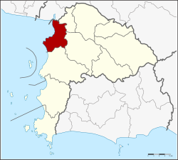
Amphoe Mueang Chon Buri
|
Amphoe Mueang Chon Buri อำเภอ เมือง ชลบุรี |
|
|---|---|
| Province: | Chon Buri |
| Surface: | 228.8 km² |
| Residents: | 308,630 (2013) |
| Population density : | 1072 U./km² |
| ZIP : | 20131, 20130, 20000 |
| Geocode : | 2001 |
| map | |

|
|
Amphoe Mueang Chon Buri ( Thai : อำเภอ เมือง ชลบุรี ) is a district ( Amphoe - Administrative District) in Chon Buri Province . The province of Chon Buri is located in the eastern region of central Thailand . The capital of Chon Buri Province is also called Chon Buri .
geography
Neighboring districts are (from north clockwise): Amphoe Bang Pakong of Chachoengsao Province and Amphoe Phan Thong , Ban Bueng and Si Racha province Chon Buri. To the west lies the Gulf of Thailand .
education
The main campus of Burapha University is located in the Amphoe Mueang Chon Buri .
Sports
This district is home to Chonburi Stadium, home of the first division football club FC Chonburi .
administration
Provincial Administration
The district of Mueang Chon Buri is divided into 18 tambon ("subdistricts" or "parishes"), which are further subdivided into 122 muban ("villages").
| No. | Surname | Thai | Muban | Pop. |
|---|---|---|---|---|
| 1. | Bang Pla Soi | บาง ปลา สร้อย | - | 16,989 |
| 2. | Makham Yong | มะขาม หย่ง | - | 6,710 |
| 3. | Ban Khot | บ้าน โขด | - | 6,764 |
| 4th | Saen Suk | แสนสุข | 15th | 35,774 |
| 5. | Ban Suan | บ้าน สวน | 10 | 62,283 |
| 6th | Nong Ri | หนอง รี | 14th | 14,123 |
| 7th | Well Pa | นา ป่า | 12 | 34,227 |
| 8th. | Nong Khang Khok | หนอง ข้าง คอก | 7th | 7,382 |
| 9. | Don Hua Lo | ดอน หัว ฬ่ อ | 7th | 10,463 |
| 10. | Nong Mai Daeng | หนอง ไม้แดง | 7th | 11,583 |
| 11. | Bang Sai | บาง ทราย | 6th | 12,663 |
| 12. | Khlong Tamru | คลอง ตำ ห รุ | 6th | 7,790 |
| 13. | Mueang | เหมือง | 5 | 11,851 |
| 14th | Ban Puek | บ้าน ปึก | 7th | 7,548 |
| 15th | Huai Kapi | ห้วย กะปิ | 7th | 21,078 |
| 16. | Samet | เสม็ด | 8th | 32,046 |
| 17th | Ang Sila | อ่าง ศิลา | 5 | 5,661 |
| 18th | Samnak Bok | สำนัก บก | 6th | 3,695 |
Local administration
There are four municipalities with "city" status ( Thesaban Mueang ) in the district:
- Chon Buri (Thai: เทศบาล เมือง ชลบุรี ) consisting of the complete Tambon Bang Pla Soi, Makham Yong, Ban Khot.
- Saen Suk (Thai: เทศบาล เมือง แสนสุข ) consisting of the complete tambon Saen Suk and the parts of the Tambon Mueang, Huai Kapi.
- Ban Suan (Thai: เทศบาล เมือง บ้าน สวน ) consisting of the complete tambon Ban Suan and parts of the Tambon Nong Ri, Nong Khang Khok.
- Ang Sila (Thai: เทศบาล เมือง อ่าง ศิลา ) consisting of the complete Tambon Ban Puek, Ang Sila and the parts of the Tambon Huai Kapi, Samet.
There are eight municipalities with "small town" status ( Thesaban Tambon ) in the district:
- Mueang (Thai: เทศบาล ตำบล เหมือง ) consisting of parts of the Tambon Mueang.
- Khlong Tamru (Thai: เทศบาล ตำบล คลอง ตำ ห รุ ) consisting of parts of the Tambon Khlong Tamru.
- Bang Sai (Thai: เทศบาล ตำบล บาง ทราย ) consisting of the complete Tambon Bang Sai.
- Nong Mai Daeng (Thai: เทศบาล ตำบล หนอง ไม้แดง ) consisting of the complete Tambon Nong Mai Daeng.
- Na Pa (Thai: เทศบาล ตำบล นา ป่า ) consisting of the complete Tambon Na Pa.
- Huai Kapi (Thai: เทศบาล ตำบล ห้วย กะปิ ) consisting of parts of the tambon Huai Kapi.
- Don Hua Lo (Thai: เทศบาล ตำบล ดอน หัว ฬ่ อ ) consisting of the complete tambon Don Hua Lo.
- Samet (Thai: เทศบาล ตำบล เสม็ด ) consisting of parts of the Tambon Samet.
There are also four " tambon administration organizations " ( องค์การ บริหาร ส่วน ตำบล - Tambon Administrative Organizations, TAO)
- Nong Ri (Thai: องค์การ บริหาร ส่วน ตำบล หนอง รี ) consisting of parts of the Tambon Nong Ri.
- Nong Khang Khok (Thai: องค์การ บริหาร ส่วน ตำบล หนอง ข้าง คอก ) consisting of parts of the Tambon Nong Khang Khok.
- Khlong Tamru (Thai: องค์การ บริหารส่วน ตำบล คลอง ตำ ห รุ ) consisting of parts of the Tambon Khlong Tamru.
- Samnak Bok (Thai: องค์การ บริหาร ส่วน ตำบล สำนัก บก ) consisting of the complete tambon Samnak Bok.
Individual evidence
- ↑ 2013 population statistics ( Thai ) Department of Provincial Administration. Retrieved October 9, 2014.
Web links
Coordinates: 13 ° 22 ′ N , 100 ° 59 ′ E