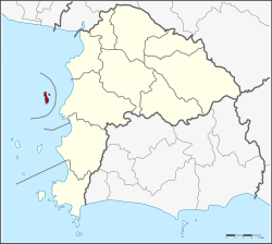
Amphoe Ko Sichang
|
Ko Sichang เกาะสีชัง |
|
|---|---|
| Province: | Chonburi |
| Surface: | 17.3 km² |
| Residents: | 4,775 (2013) |
| Population density : | 291 U / km² |
| ZIP : | 20120 |
| Geocode : | 2008 |
| map | |

|
|
Amphoe Ko Sichang ( Thai : อำเภอ เกาะสีชัง ) is a district ( amphoe - administrative district) in Chonburi Province ( Changwat ) . The Chon Buri Province is located in the east of the central region of Thailand .
geography
Amphoe Ko Sichang consists mainly of the island (Ko) Sichang in the Gulf of Thailand , about 12 km off the west coast of Amphoe Si Racha .
Surrounding small islands
- Ko Samphan Yue - เกาะ สั ม ปัน ยื้อ
- Ko Kham Noi - เกาะ ขาม น้อย
- Ko Kham Yai - เกาะ ขาม ใหญ่
- Ko Phrong - เกาะ ปรง
- Ko Khangkhao - เกาะ ค้างคาว
- Ko Thai Tamuen - เกาะ ท้าย ตา หมื่น
- Ko Yai Thao - เกาะ ยาย ท้าว
- Ko Ran Dok Mai - เกาะ ร้าน ดอกไม้
- Ko Nok - เกาะ นก
history
The British diplomat John Crawfurd visited the island in 1822 during a mission which he described in his book Journal of an embassy from the Governor-General of India to the courts of Siam and Cochin-China: exhibiting a view of the actual state of those kingdoms describes. In his book he reports on Francis Buchanan-Hamilton , who referred to the islands of the Ko Sichang district as the Dutch islands and Ko Sichang itself as Amsterdam , which was the basis for the frequent visits of the ships of the Dutch East India Company .
After the birth of his son, King Rama V built a summer residence on the island called Phra Chuthathut. The royal residence was abandoned in 1893 after the French occupied the island due to a conflict with Thailand. The reason for the conflict was the control over the neighboring island of Laos (island) . In 1900 the residence was demolished and rebuilt in Bangkok, where it is now known as the Vimanmek Palace .
The island was originally a "branch district" ( King Amphoe ) of the Mueang District of Samut Prakan Province . On January 1, 1943, he was assigned to the Si Racha District of Chonburi Province . On July 4, 1994, Ko Sichang was granted full amphoe status.
administration
Provincial Administration
Ko Sichang County consists of only one tambon ("subdistrict" or "municipality"), which is further divided into seven muban ("villages").
| No. | Surname | Thai | Muban | Pop. |
|---|---|---|---|---|
| 1. | Tha Thewawong | ท่า เทว วงษ์ | 7th | 4,775 |
Local administration
There is one municipality with "small town" status ( Thesaban Tambon ) in the district:
- Ko Sichang (Thai: เทศบาล ตำบล เกาะสีชัง ) consisting of the complete Tambon Tha Thewawong.
Individual evidence
- ^ History of Koh Sichang. Accessed June 19, 2018 .
- ↑ ประกาศ กระทรวง มหาดไทย เรื่อง ให้ กิ่ง อำเภอ เกาะสีชัง ขึ้น กับ อำเภอ ศรีราชา จังหวัด ชลบุรี Royal Gazette, Vol. 60, Issue 1 ง January 1, 1943, p. 6 (in Thai)
- ↑ = พระราชกฤษฎีกา ตั้ง อำเภอ เปือยน้อย ... และ อำเภอ ศรีวิไล พ.ศ. ๒๕๓๗ Royal Gazette, Vol. 111, Ed. 21 ก June 3, 1994, pp. 32–35 (in Thai)
- ↑ 2013 population statistics ( Thai ) Department of Provincial Administration. Retrieved October 9, 2014.
Web links
Coordinates: 13 ° 10 ' N , 100 ° 48' E