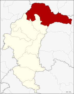
Loeng Nok Tha district
|
Loeng Nok Tha เลิงนกทา |
|
|---|---|
| Province: | Yasothon |
| Surface: | 942.8 km² |
| Residents: | 95,873 (2013) |
| Population density : | 99.4 U / km² |
| ZIP : | 35120 |
| Geocode : | 3508 |
| map | |

|
|
Amphoe Loeng Nok Tha (in Thai อำเภอ เลิงนกทา ) is a district ( Amphoe - Administrative District) in Yasothon Province . The province of Yasothon is located in the eastern part of the northeast region of Thailand , the so-called Isan .
geography
Neighboring districts (from north clockwise): Amphoe Nong Sung , Nikhom Kham Soi and Don Tan of Mukdahan Province , to the Amphoe Chanuman and Senangkhanikhom the province of Amnat Charoen , to the Amphoe Thai Charoen and Kut Chum in the province of Yasothon, as well as Amphoe Nong Phok in the province of Roi Et .
Loeng Nok Tha is located about 69 km northeast of the Amphoe Mueang Yasothon and about 600 km northeast of Bangkok .
history
Loeng Nok Tha was set up on September 1, 1937, initially as a "branch circle" ( King Amphoe ) under the administration of the Amphoe Mueang Amnat Charoen in the Ubon Ratchathani Province . At that time it consisted of the three tambon Kut Chiang Mi, Bung Kha and Som Pho. On November 1, 1947, Loeng Nok Tha was promoted to an Amphoe of Ubon Ratchathani Province. When the new Yasothon Province was created in 1972, Loeng Nok Tha was one of the six original districts.
administration
Provincial Administration
Loeng Nok Tha County is divided into ten tambon ("subdistricts" or "parishes"), which are further subdivided into 143 Muban ("villages").
| No. | Surname | Thai | Muban | Pop. |
|---|---|---|---|---|
| 2. | Bung Kha | บุ่ง ค้า | - | 13,247 |
| 3. | Sawat | สวาท | 16 | 13,337 |
| 5. | Hong Saeng | ห้อง แซง | 4th | 11,420 |
| 6th | Samakkhi | สามัคคี | 15th | 7,412 |
| 7th | Kut Chiang Mi | กุด เชียง หมี | 12 | 7,657 |
| 10. | Sam Yaek | สาม แยก | - | 12,284 |
| 11. | Kut Hae | กุด แห่ | 13 | 8,520 |
| 12. | Khok Samran | โคก สำราญ | 4th | 10,439 |
| 13. | Sang Ming | สร้าง มิ่ง | - | 5,977 |
| 14th | Si Kaeo | ศรี แก้ว | 10 | 5,580 |
Note: Some of the Muban's data are not yet available.
Local administration
There are nine municipalities with "small town" status ( Thesaban Tambon ) in the district:
- Bung Kha (Thai: เทศบาล ตำบล บุ่ง ค้า ), consisting of the entire Tambon Bung Kha.
- Sawat (Thai: เทศบาล ตำบล สวาท ), consisting of parts of the Tambon Sawat.
- Hong Saeng (Thai: เทศบาล ตำบล ห้อง แซง ), consisting of the entire tambon Hong Saeng.
- Samakkhi (Thai: เทศบาล ตำบล สามัคคี ), consisting of the entire tambon Sammakkhi.
- Kut Chiang Mi (Thai: เทศบาล ตำบล กุด เชียง หมี ), consisting of the entire tambon Kut Chiang Mi.
- Kut Hae (Thai: เทศบาล ตำบล กุด แห่ ), consisting of the entire tambon Kut Hae.
- Si Kaeo (Thai: เทศบาล ตำบล ศรี แก้ว ), consisting of the entire tambon Si Kaeo.
- Loeng Nok Tha (Thai: เทศบาล ตำบล เลิงนกทา ), consisting of the remaining parts of the Tambon Sawat.
- Sam Yaek (Thai: เทศบาล ตำบล สาม แยก ), consisting of parts of the Tambon Sam Yaek.
There are also three " Tambon Administrative Organizations " ( องค์การ บริหาร ส่วน ตำบล - Tambon Administrative Organizations, TAO):
- Sam Yaek (Thai: องค์การ บริหาร ส่วน ตำบล สาม แยก )
- Khok Samran (Thai: องค์การ บริหาร ส่วน ตำบล โคก สำราญ )
- Sang Ming (Thai: องค์การ บริหาร ส่วน ตำบล สร้าง มิ่ง )
Individual evidence
- ↑ ประกาศ กระทรวง มหาดไทย เรื่อง ตั้ง กิ่ง อำเภอ เลิก นก ทา . In: Royal Gazette . 54, No. 0 ง , 23 August 1937, pp. 1155-1156.
- ↑ ประกาศ สำนัก นายกรัฐมนตรี เรื่อง ยก ฐานะ กิ่ง อำเภอ ขึ้น เป็น อำเภอ . In: Royal Gazette . 64, No. 50 ง , October 21, 1947, pp. 2661–2662.
- ↑ 2013 population statistics ( Thai ) Department of Provincial Administration. Retrieved August 4, 2014.
Web links
Coordinates: 16 ° 12 ' N , 104 ° 33' E