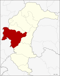
Amphoe Mueang Yasothon
|
Mueang Yasothon เมือง ยโสธร |
|
|---|---|
| Province: | Yasothon |
| Surface: | 578.22 km² |
| Residents: | 130,358 (2013) |
| Population density : | 36.55 U / km² |
| ZIP : | 35000 |
| Geocode : | 3501 |
| map | |

|
|
Amphoe Mueang Yasothon ( Thai : อำเภอ เมือง ยโสธร ) is a district ( Amphoe - Administrative District) in the Yasothon Province . The province of Yasothon is located in the northeast region of Thailand , the so-called Isan .
geography
Yasothon lies in the middle of a barren plain in the Isan. The distance to the capital Bangkok is a good 500 kilometers.
Neighboring counties are (clockwise from north) the Amphoe Sai Mun , Kut Chum , Pa Tio and Kham Khuean Kaeo in the province of Yasothon, as well as the Amphoe Phanom Phrai and Selaphum in the province of Roi Et .
history
The province was formed in 1972 when it was separated from Ubon Ratchathani .
administration
Provincial Administration
Mueang Yasothon County is divided into 18 tambon ("subdistricts" or "parishes"), which are further subdivided into 190 muban ("villages").
| No. | Surname | Thai | Muban | Pop. |
|---|---|---|---|---|
| 1. | Nai Mueang | ใน เมือง | - | 20,403 |
| 2. | Nam Kham Yai | น้ำ คำ ใหญ่ | - | 9,307 |
| 3. | Tat Thong | ตาด ทอง | 13 | 9,611 |
| 4th | Samran | สำราญ | 11 | 7,644 |
| 5. | Kho Nuea | ค้อ เหนือ | - | 7,753 |
| 6th | You Thung | ดู่ ทุ่ง | - | 5,626 |
| 7th | Doet | เดิ ด | 8th | 11,397 |
| 8th. | Khandai Yai | ขั้น ได ใหญ่ | 9 | 4,793 |
| 9. | Thung Tae | ทุ่ง แต้ | - | 5,320 |
| 10. | Sing | สิงห์ | - | 6,086 |
| 11. | Well, Samai | นา สะ ไม ย์ | 13 | 5.511 |
| 12. | Khueang Kham | เขื่อง คำ | 2 | 8,468 |
| 13. | Nong Hin | หนอง หิน | 9 | 4,553 |
| 14th | Nong Khu | หนอง คู | - | 5,737 |
| 15th | Khum Ngoen | ขุม เงิน | - | 5,314 |
| 16. | Thung Nang Ok | ทุ่ง นาง โอ ก | - | 4,825 |
| 17th | Nong Ruea | หนองเรือ | - | 3,665 |
| 18th | Nong Pet | หนอง เป็ด | 9 | 4,345 |
Note: Some of the Muban's data are not yet available.
Local administration
There is one commune with "city" status ( Thesaban Mueang ) in the district:
- Yasothon (Thai: เทศบาล เมือง ยโสธร ) consists of the entire Tambon Nai Mueang.
There are five municipalities with "small town" status ( Thesaban Tambon ) in the district:
- Nam Kham Yai (Thai: เทศบาล ตำบล น้ำ คำ ใหญ่ ) consists of the entire tambon Nam Kham Yai.
- Tat Thong (Thai: เทศบาล ตำบล ตาด ทอง ) consists of the entire tambon Tat Thong.
- Samran (Thai: เทศบาล ตำบล สำราญ ) consists of the entire tambon Samran.
- Doet (Thai: เทศบาล ตำบล เดิ ด ) consists of the entire tambon doet.
- Thung Tae (Thai: เทศบาล ตำบล ทุ่ง แต้ ) consists of the entire Tambon Thung Tae
There are also twelve " Tambon Administrative Organizations " ( องค์การ บริหาร ส่วน ตำบล - Tambon Administrative Organizations, TAO):
- Kho Nuea (Thai: องค์การ บริหาร ส่วน ตำบล ค้อ เหนือ )
- Du Thung (Thai: องค์การ บริหาร ส่วน ตำบล ดู่ ทุ่ง )
- Khandai Yai (Thai: องค์การ บริหาร ส่วน ตำบล ขั้น ได ใหญ่ )
- Sing (Thai: องค์การ บริหาร ส่วน ตำบล สิงห์ )
- Na Samai (Thai: องค์การ บริหาร ส่วน ตำบล นา สะ ไม ย์ )
- Khueang Kham (Thai: องค์การ บริหาร ส่วน ตำบล เขื่อง คำ )
- Nong Hin (Thai: องค์การ บริหาร ส่วน ตำบล หนอง หิน )
- Nong Khu (Thai: องค์การ บริหาร ส่วน ตำบล หนอง คู )
- Khum Ngoen (Thai: องค์การ บริหาร ส่วน ตำบล ขุม เงิน )
- Thung Nang Ok (Thai: องค์การ บริหาร ส่วน ตำบล ทุ่ง นาง โอ ก )
- Nong Ruea (Thai: องค์การ บริหาร ส่วน ตำบล หนองเรือ )
- Nong Pet (Thai: องค์การ บริหาร ส่วน ตำบล หนอง เป็ด )
Individual evidence
- ↑ 2013 population statistics ( Thai ) Department of Provincial Administration. Retrieved August 4, 2014.
Web links
Coordinates: 15 ° 48 ' N , 104 ° 9' E