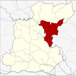
Amphoe Selaphum
|
Selaphum เสลภูมิ |
|
|---|---|
| Province: | Roi Et |
| Surface: | 792.338 km² |
| Residents: | 122,095 (2013) |
| Population density : | 154.1 U / km² |
| ZIP : | 45120 |
| Geocode : | 4510 |
| map | |

|
|
Amphoe Selaphum ( Thai : อำเภอ เสลภูมิ ) is a district ( Amphoe - administrative district) in the east of the province of Roi Et . The province of Roi Et is located in the northeast region of Thailand , the so-called Isan .
geography
Amphoe Selaphum borders the following counties (from the south clockwise): Amphoe Phanom Phrai , At Samat , Thung Khao Luang , Thawat Buri , Chiang Khwan , Pho Chai , Phon Thong and Nong Phok in the province of Roi Et, as well as the Amphoe Kut Chum , Sai Mun and Mueang Yasothon the province of Yasothon .
history
The history of the Selaphum district goes back to the village of Ban Khao Din Bueng Don (Thai: บ้าน เขา ดิน บึง โดน ), which was named after an island in the Bueng Don swamp . In 1879 it emerged from Mueang Selaphum Nikhom (Thai: เสลภูมิ, ), which was renamed Selaphum in 1912 and upgraded to an Amphoe in 1914.
education
The Rajabhat University of Roi Et is located in Amphoe Selaphum .
Administrative units
Provincial Administration
The Selaphum district is divided into 18 tambon ("sub-districts" or "municipalities"), which are further divided into 235 muban ("villages").
| No. | Surname | Thai | Muban | Pop. |
|---|---|---|---|---|
| 1. | sound | กลาง | 11 | 6,718 |
| 2. | Well ngam | นา งาม | 16 | 7,925 |
| 3. | Mueang Phrai | เมือง ไพร | 14th | 6,383 |
| 4th | Well saeng | นา แซง | 14th | 5,633 |
| 5. | Well, Mueang | นา เมือง | 20th | 10,107 |
| 6th | Wang Luang | วังหลวง | 18th | 6.176 |
| 7th | Tha Muang | ท่าม่วง | 11 | 4,966 |
| 8th. | Khwao | ขวา ว | 16 | 9,167 |
| 9. | Pho Thong | โพธิ์ทอง | 14th | 8,074 |
| 10. | Phu Ngoen | ภู เงิน | 18th | 11,872 |
| 11. | Ko Kaeo | เกาะ แก้ว | 14th | 9,541 |
| 12. | Well Loeng | นา เลิ ง | 10 | 4,817 |
| 13. | Lao Noi | เหล่า น้อย | 10 | 5,679 |
| 14th | Si Wilai | ศรี วิลัย | 11 | 4,696 |
| 15th | Nong Luang | หนอง หลวง | 9 | 3,073 |
| 16. | Phon Sawan | พรสวรรค์ | 9 | 4,446 |
| 17th | Khwan Mueang | ขวัญเมือง | 11 | 6,752 |
| 18th | Bueng Kluea | บึง เกลือ | 9 | 6,070 |
Local administration
There are ten municipalities with "small town" status ( Thesaban Tambon ) in the district:
- Na Saeng (Thai: เทศบาล ตำบล นา แซง ) consisting of the complete tambon Na Saeng.
- Na Mueang (Thai: เทศบาล ตำบล นา เมือง ) consisting of parts of the Tambon Na Mueang.
- Wang Luang (Thai: เทศบาล ตำบล วังหลวง ) consisting of the complete tambon Wang Luang.
- Tha Muang (Thai: เทศบาล ตำบล ท่าม่วง ) consisting of the complete Tambon Tha Muang.
- Ko Kaeo (Thai: เทศบาล ตำบล เกาะ แก้ว ) consisting of the complete tambon Ko Kaeo.
- Nong Luang (Thai: เทศบาล ตำบล หนอง หลวง ) consisting of the complete Tambon Nong Luang.
- Phon Sawan (Thai: เทศบาล ตำบล พรสวรรค์ ) consisting of the complete tambon Phon Sawan.
- Selaphum (Thai: เทศบาล ตำบล เสลภูมิ ) consisting of the complete Tambon Klang, Khwan Mueang and parts of Tambon Na Mueang.
- Khwao (Thai: เทศบาล ตำบล ขวา ว ) consisting of the complete tambon Khwao.
- Mueang Phrai (Thai: เทศบาล ตำบล เมือง ไพร ) consisting of the complete tambon Mueang Phrai.
There are also seven " Tambon Administrative Organizations " ( องค์การ บริหาร ส่วน ตำบล - Tambon Administrative Organizations, TAO):
- Na Ngam (Thai: องค์การ บริหาร ส่วน ตำบล นา งาม ) consisting of the complete Tambon Na Ngam.
- Pho Thong (Thai: องค์การ บริหาร ส่วน ตำบล โพธิ์ทอง ) consisting of the complete Tambon Pho Thong.
- Phu Ngoen (Thai: องค์การ บริหาร ส่วน ตำบล ภู เงิน ) consisting of the complete tambon Phu Ngoen.
- Na Loeng (Thai: องค์การ บริหาร ส่วน ตำบล นา เลิ ง ) consisting of the complete Tambon Na Loeng.
- Lao Noi (Thai: องค์การ บริหาร ส่วน ตำบล เหล่า น้อย ) consisting of the complete tambon Lao Noi.
- Si Wilai (Thai: องค์การ บริหาร ส่วน ตำบล ศรี วิลัย ) consisting of the complete tambon Si Wilai.
- Bueng Kluea (Thai: องค์การ บริหาร ส่วน ตำบล บึง เกลือ ) consisting of the complete tambon Bueng Kluea.
Individual evidence
- ↑ 2013 population statistics ( Thai ) Department of Provincial Administration. Retrieved August 3, 2014.
Web links
Coordinates: 16 ° 2 ′ N , 103 ° 56 ′ E
