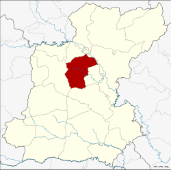
Amphoe Thawat Buri
|
Thawat Buri ธวัชบุรี |
|
|---|---|
| Province: | Roi Et |
| Surface: | 374.0 km² |
| Residents: | 68,268 (2013) |
| Population density : | 183.0 U / km² |
| ZIP : | 45170 |
| Geocode : | 4505 |
| map | |

|
|
Amphoe Thawat Buri ( Thai : อำเภอ ธวัชบุรี ) is a district ( amphoe - administrative district) in the province of Roi Et . The province of Roi Et is located in the northeast region of Thailand , the so-called Isan .
geography
Amphoe Thawat Buri borders the following counties (clockwise from north): Amphoe Chiang Khwan , Selaphum , Thung Khao Luang , At Samat and Mueang Roi Et . All Amphoe are in the province of Roi Et.
history
The district was renamed from Uthai Roi Et ( อุ ไทย ร้อยเอ็ด ) to Saeng Badan ( แซง บาดาล ) in 1913 . In 1939 it was given its current name Thawat Buri.
Administrative units
Provincial Administration
Thawat Buri County is divided into twelve tambon ("subdistricts" or "parishes"), which are further subdivided into 147 muban ("villages").
| No. | Surname | Thai | Muban | Pop. |
|---|---|---|---|---|
| 1. | Niwet | นิเวศน์ | 17th | 9,296 |
| 2. | Thong Thani | ธง ธานี | 10 | 6,175 |
| 3. | Nong Phai | หนองไผ่ | 18th | 7,587 |
| 4th | Thawat Buri | ธวัชบุรี | 12 | 4,737 |
| 6th | About Mao | อุ่ ม เม้า | 15th | 7,456 |
| 7th | Ma-ue | มะ อึ | 10 | 5,513 |
| 10. | Khwao Thung | เข วา ทุ่ง | 10 | 4,462 |
| 15th | Phaisan | ไพศาล | 9 | 3,973 |
| 17th | Mueang Noi | เมือง น้อย | 13 | 5,155 |
| 20th | Bueng Nakhon | บึง นคร | 13 | 6,175 |
| 22nd | Ratchathani | ราชธานี | 11 | 3,653 |
| 24. | Nong Phok | หนองพอก | 9 | 4,086 |
Note: The missing numbers (geocodes) refer to the tambon that today belong to Chiang Khwan and Thung Khao Luang.
Local administration
There are five municipalities with "small town" status ( Thesaban Tambon ) in the district:
- Thong Thani (Thai: เทศบาล ตำบล ธง ธานี ) consisting of the complete Tambon Thong Thani and parts of the Tambon Bueng Nakhon.
- Ban Niwet (Thai: เทศบาล ตำบล บ้าน นิเวศน์ ) consisting of parts of the Tambon Niwet.
- Um Mao (Thai: เทศบาล ตำบล อุ่ ม เม้า ) consisting of the complete tambon Um Mao.
- Ma-ue (Thai: เทศบาล ตำบล มะ อึ ) consisting of the complete tambon Ma-ue.
- Niwet (Thai: เทศบาล ตำบล นิเวศน์ ) consisting of parts of the tambon Niwet.
There are also eight " Tambon Administrative Organizations " ( องค์การ บริหาร ส่วน ตำบล - Tambon Administrative Organizations, TAO):
- Nong Phai (Thai: องค์การ บริหาร ส่วน ตำบล หนองไผ่ ) consisting of the complete Tambon Nong Phai.
- Thawat Buri (Thai: องค์การ บริหาร ส่วน ตำบล ธวัชบุรี ) consisting of the complete Tambon Thawat Buri.
- Khwao Thung (Thai: องค์การ บริหาร ส่วน ตำบล เข วา ทุ่ง ) consisting of the complete tambon Khwao Thung.
- Phaisan (Thai: องค์การ บริหาร ส่วน ตำบล ไพศาล ) consisting of the complete Tambon Phaisan.
- Mueang Noi (Thai: องค์การ บริหาร ส่วน ตำบล เมือง น้อย ) consisting of the complete tambon Mueang Noi.
- Bueng Nakhon (Thai: องค์การ บริหาร ส่วน ตำบล บึง นคร ) consisting of parts of the Tambon Bueng Nakhon.
- Ratchathani (Thai: องค์การ บริหาร ส่วน ตำบล ราชธานี ) consisting of the complete tambon Ratchathani.
- Nong Phok (Thai: องค์การ บริหาร ส่วน ตำบล หนองพอก ) consisting of the complete Tambon Thung Khao Luang.
Individual evidence
- ↑ แจ้ง ความ กระทรวง มหาดไทย เรื่อง เปลี่ยน นาม อำเภอ . In: Royal Gazette . 30, No. 0 ง , October 19, 1913, pp. 1619–1620.
- ↑ พระราชกฤษฎีกา เปลี่ยน นาม อำเภอ กิ่ง อำเภอ และ ตำบล บาง แห่ง พุทธศักราช ๒๔๘๒ . In: Royal Gazette . 56, No. 0 ก , April 17, 1939, pp. 354-364.
- ↑ 2013 population statistics ( Thai ) Department of Provincial Administration. Retrieved August 3, 2014.
Web links
Coordinates: 16 ° 2 ′ N , 103 ° 45 ′ E
