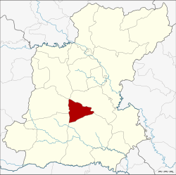
Amphoe Mueang Suang
|
Mueang Suang เมืองสรวง |
|
|---|---|
| Province: | Roi Et |
| Surface: | 209.4 km² |
| Residents: | 23,143 (2013) |
| Population density : | 113.4 U / km² |
| ZIP : | 45220 |
| Geocode : | 4512 |
| map | |

|
|
Amphoe Mueang Suang ( Thai : อำเภอ เมืองสรวง ) is a district ( amphoe - administrative district) in the province of Roi Et . The province of Roi Et is located in the northeast region of Thailand , the so-called Isan .
geography
Neighboring counties (clockwise from the north): the Amphoe At Samat , Suwannaphum , Kaset Wisai and Chaturaphak Phiman . All Amphoe are in the province of Roi Et.
history
In the past, Suang was one of the eleven Mueang (city-states) that were subordinate to the Mueang Roi Et.
On March 15, 1973, the "Branch Circle" ( King Amphoe ) Mueang Suang was established by separating the three tambon Nong Phue, Nong Hin and Khu Mueang from the Amphoe Suwannaphum. It was promoted to Amphoe on March 25, 1979.
traffic
The road 215, from Amphoe Suwannaphum (south) 214, leads from the provincial capital Roi Et to Surin, the capital of the province of Surin in the south . Apart from this connection, which is important for the Isan, there are roads to At Samat (east) and to Chaturaphak Phiman (west).
Buses with regular timetables also cross the Amphoe. An air-conditioned bus runs several times a day on the main road from Roi Et to Surin with a stop in Mueang Suang. A songthaeo drives every hour from Roi Et via Mueang Suang to Suwannaphum.
Administrative units
Provincial Administration
Mueang Suang County is divided into five tambon ("subdistricts" or "parishes"), which are further subdivided into 49 Muban ("villages").
| No. | Surname | Thai | Muban | Pop. |
|---|---|---|---|---|
| 1. | Nong Phue | หนอง ผื อ | 9 | 4,449 |
| 2. | Nong Hin | หนอง หิน | 10 | 4,608 |
| 3. | Khu Mueang | คูเมือง | 10 | 5,051 |
| 4th | Kok Kung | กก กุ ง | 11 | 4,094 |
| 5. | Mueang Suang | เมืองสรวง | 9 | 4,941 |
Local administration
There are four municipalities with "small town" status ( Thesaban Tambon ) in the district:
- Nong Hin (Thai: เทศบาล ตำบล หนอง หิน ) consisting of the complete Tambon Nong Hin.
- Khu Mueang (Thai: เทศบาล ตำบล คูเมือง ) consisting of the complete tambon Khu Mueang.
- Kok Kung (Thai: เทศบาล ตำบล กก กุ ง ) consisting of the complete Tambon Kok Kung.
- Mueang Suang (Thai: เทศบาล ตำบล เมืองสรวง ) consisting of the complete Tambon Nong Phue, Mueang Suang.
Individual evidence
- ↑ ประกาศ กระทรวง มหาดไทย เรื่อง แบ่ง ท้องที่ อำเภอ สุวรรณภูมิ จังหวัด ร้อยเอ็ด ตั้ง เป็น กิ่ง อำเภอ เมืองสรวง . In: Royal Gazette . 90, No. 26 ง , March 20, 1973, p. 817.
- ↑ พระราชกฤษฎีกา ตั้ง อำเภอ หนองกุงศรี อำเภอ ไทรงาม อำเภอ บ้านฝาง อำเภอ อุบลรัตน์ อำเภอ เวียงชัย อำเภอ ดอยเต่า อำเภอ นิคมคำสร้อย อำเภอ นาหว้า อำเภอ เสิงสาง อำเภอ ศรีสาคร อำเภอ บึงสามพัน อำเภอ นาดูน อำเภอ อำเภอ ค้อวัง อำเภอ โพธิ์ชัย อำเภอ อำเภอ เมืองสรวง อำเภอ ปลวกแดง อำเภอ ยางชุมน้อย อำเภอ กาบเชิง อำเภอ สุวรรณคูหา และ อำเภอ กุดข้าวปุ้น พ.ศ. ๒๕๒๒ . In: Royal Gazette . 96, No. 42 ก ฉบับ พิเศษ (special), March 25 1979, pp. 19-24.
- ↑ 2013 population statistics ( Thai ) Department of Provincial Administration. Retrieved August 3, 2014.
Web links
Coordinates: 15 ° 49 ' N , 103 ° 43' E
