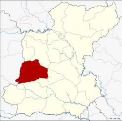
Amphoe Chaturaphak Phiman
|
Chaturaphak Phiman จตุร พักตร พิมาน |
|
|---|---|
| Province: | Roi Et |
| Surface: | 522.0 km² |
| Residents: | 80,500 (2013) |
| Population density : | 149.9 U / km² |
| ZIP : | 45180 |
| Geocode : | 4504 |
| map | |

|
|
Amphoe Chaturaphak Phiman ( Thai : อำเภอ จตุร พักตร พิมาน ) is a district ( amphoe - administrative district) in the west of the province of Roi Et . The province of Roi Et is located in the northeast region of Thailand , the so-called Isan .
geography
Amphoe Chaturaphak Phiman borders the following counties (from north clockwise): Amphoe Si Somdet , Mueang Roi Et , Mueang Suang and Kaset Wisai in the province of Roi Et Province, and Amphoe Wapi Pathum in the province of Maha Sarakham .
history
The county was renamed Chaturaphak Phiman from Hua Chang in 1939.
Administrative units
Provincial Administration
The district of Chaturaphak Phiman is divided into twelve tambon ("subdistricts" or "communities"), which are further subdivided into 150 muban ("villages").
| No. | Surname | Thai | Muban | Pop. |
|---|---|---|---|---|
| 1. | Hua Chang | หัว ช้าง | 15th | 13.094 |
| 2. | Nong Phue | หนอง ผื อ | 11 | 7,511 |
| 3. | Mueang Hong | เมือง หงส์ | 17th | 7,311 |
| 4th | Khok Lam | โคก ล่าม | 16 | 7,370 |
| 5. | Nam Sai | น้ำ ใส | 10 | 4,824 |
| 6th | Dong Daeng | ดง แดง | 16 | 8,828 |
| 7th | Dong sound | ดง กลาง | 10 | 5,905 |
| 8th. | Pa Sang | ป่า สังข์ | 14th | 5,863 |
| 9. | I Ngong | อี ง่อง | 9 | 4,343 |
| 10. | Lin Fa | ลิ้น ฟ้า | 9 | 4,536 |
| 11. | You noi | ดู่ น้อย | 14th | 6,597 |
| 12. | Si Khot | ศรี โคตร | 9 | 4,318 |
Local administration
There are seven municipalities with "small town" status ( Thesaban Tambon ) in the district:
- Nong Phue (Thai: เทศบาล ตำบล หนอง ผื อ ) consisting of the complete Tambon Nong Phue.
- Mueang Hong (Thai: เทศบาล ตำบล เมือง หงส์ ) consisting of the complete tambon Mueang Hong.
- Lin Fa (Thai: เทศบาล ตำบล ลิ้น ฟ้า ) consisting of the complete tambon Lin Fa.
- Chaturaphak Phiman (Thai: เทศบาล ตำบล จตุร พักตร พิมาน ) consisting of parts of the Tambon Hua Chang.
- Hua Chang (Thai: เทศบาล ตำบล หัว ช้าง ) consisting of parts of the Tambon Hua Chang.
- Khok Lam (Thai: เทศบาล ตำบล โคก ล่าม ) consisting of the complete tambon Khok Lam.
- Dong Daeng (Thai: เทศบาล ตำบล ดง แดง ) consisting of the complete tambon Dong Daeng.
There are also six " Tambon Administrative Organizations " ( องค์การ บริหาร ส่วน ตำบล - Tambon Administrative Organizations, TAO):
- Nam Sai (Thai: องค์การ บริหาร ส่วน ตำบล น้ำ ใส ) consisting of the complete Tambon Nam Sai.
- Dong Klang (Thai: องค์การ บริหาร ส่วน ตำบล ดง กลาง ) consisting of the complete Tambon Dong Klang.
- Pa Sang (Thai: องค์การ บริหาร ส่วน ตำบล ป่า สังข์ ) consisting of the complete Tambon Pa Sang.
- I Ngong (Thai: องค์การ บริหาร ส่วน ตำบล อี ง่อง ) consisting of the complete tambon I Ngong.
- Du Noi (Thai: องค์การ บริหาร ส่วน ตำบล ดู่ น้อย ) consisting of the complete Tambon Du Noi.
- Si Khot (Thai: องค์การ บริหาร ส่วน ตำบล ศรี โคตร ) consisting of the complete tambon Si Khot.
Individual evidence
- ↑ พระราชกฤษฎีกา เปลี่ยน นาม อำเภอ กิ่ง อำเภอ และ ตำบล บาง แห่ง พุทธศักราช ๒๔๘๒ . In: Royal Gazette . 56, No. 0 ก , April 17, 1939, pp. 354-364.
- ↑ 2013 population statistics ( Thai ) Department of Provincial Administration. Retrieved August 3, 2014.
Web links
Coordinates: 15 ° 51 ' N , 103 ° 33' E
