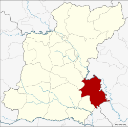
Amphoe Phanom Phrai
|
Phanom Phrai พนม ไพร |
|
|---|---|
| Province: | Roi Et |
| Surface: | 519.3 km² |
| Residents: | 73,287 (2013) |
| Population density : | 144.7 U / km² |
| ZIP : | 45140 |
| Geocode : | 4506 |
| map | |

|
|
Amphoe Phanom Phrai ( Thai : อำเภอ พนม ไพร ) is a district ( amphoe - administrative district) in the southeast of the province of Roi Et . The province of Roi Et is located in the northeast region of Thailand , the so-called Isan .
geography
Amphoe Phanom Phrai borders the following counties (from southwest clockwise): Amphoe Nong Hi , Suwannaphum , At Samat and Selaphum in the province of Roi Et, to the Amphoe Mueang Yasothon , Kham Khuean Kaeo and Maha Chana Chai in the province of Yasothon as well at Amphoe Sila Lat in the province of Si Sa Ket .
Administrative units
Provincial Administration
Phanom Phrai County is divided into 13 tambon ("subdistricts" or "parishes"), which are further subdivided into 160 muban ("villages").
| No. | Surname | Thai | Muban | Pop. |
|---|---|---|---|---|
| 1. | Phanom Phrai | พนม ไพร | 19th | 11,049 |
| 2. | Saen Suk | แสนสุข | 18th | 8,347 |
| 3. | Kut Nam Sai | กุด น้ำ ใส | 10 | 3,881 |
| 4th | Nong Thap Thai | หนอง ทัพ ไทย | 14th | 6,997 |
| 5. | Pho Yai | โพธิ์ ใหญ่ | 14th | 7.107 |
| 6th | Wari Sawat | วารี สวัสดิ์ | 11 | 4,426 |
| 7th | Khok Sawang | โคก สว่าง | 16 | 4,849 |
| 11. | Pho Chai | โพธิ์ชัย | 12 | 6,871 |
| 12. | Well nuan | นา นวล | 13 | 4,653 |
| 13. | Kham Hai | คำ ไฮ | 10 | 5,342 |
| 14th | Sa Kaeo | สระแก้ว | 9 | 3,708 |
| 15th | Kho Yai | ค้อ ใหญ่ | 7th | 2.164 |
| 17th | Hanuwan | ชานุ วรรณ | 7th | 3,893 |
Note: The missing numbers (geocodes) refer to the tambon that belong to Nong Hi today.
Local administration
There are two municipalities with "small town" status ( Thesaban Tambon ) in the district:
- Phanom Phrai (Thai: เทศบาล ตำบล พนม ไพร ) consisting of parts of the tambon Phanom Phrai.
- Pho Chai (Thai: เทศบาล ตำบล โพธิ์ชัย ) consisting of the complete Tambon Pho Chai.
There are also twelve " Tambon Administrative Organizations " ( องค์การ บริหาร ส่วน ตำบล - Tambon Administrative Organizations, TAO):
- Phanom Phrai (Thai: องค์การ บริหาร ส่วน ตำบล พนม ไพร ) consisting of parts of the tambon Phanom Phrai.
- Saen Suk (Thai: องค์การ บริหาร ส่วน ตำบล แสนสุข ) consisting of the complete tambon Saen Suk.
- Kut Nam Sai (Thai: องค์การ บริหาร ส่วน ตำบล กุด น้ำ ใส ) consisting of the complete tambon Kut Nam Sai.
- Nong Thap Thai (Thai: องค์การ บริหาร ส่วน ตำบล หนอง ทัพ ไทย ) consisting of the complete Tambon Nong Thap Thai.
- Pho Yai (Thai: องค์การ บริหาร ส่วน ตำบล โพธิ์ ใหญ่ ) consisting of the complete tambon Pho Yai.
- Wari Sawat (Thai: องค์การ บริหาร ส่วน ตำบล วารี สวัสดิ์ ) consisting of the complete tambon Wari Sawat.
- Khok Sawang (Thai: องค์การ บริหาร ส่วน ตำบล โคก สว่าง ) consisting of the complete tambon Khok Sawang.
- Na Nuan (Thai: องค์การ บริหาร ส่วน ตำบล นา นวล ) consisting of the complete Tambon Na Nuan.
- Kham Hai (Thai: องค์การ บริหาร ส่วน ตำบล คำ ไฮ ) consisting of the complete Tambon Kham Hai.
- Sa Kaeo (Thai: องค์การ บริหาร ส่วน ตำบล สระแก้ว ) consisting of the complete Sa Kaeo tambon.
- Kho Yai (Thai: องค์การ บริหาร ส่วน ตำบล ค้อ ใหญ่ ) consisting of the complete tambon Kho Yai.
- Chanuwan (Thai: องค์การ บริหาร ส่วน ตำบล ชานุ วรรณ ) consisting of the complete tambon Chanuwan.
Individual evidence
- ↑ 2013 population statistics ( Thai ) Department of Provincial Administration. Retrieved August 3, 2014.
Web links
Coordinates: 15 ° 41 ′ N , 104 ° 7 ′ E
