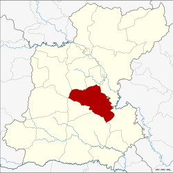
Amphoe At Samat
|
At Samat อาจสามารถ |
|
|---|---|
| Province: | Roi Et |
| Surface: | 454.4 km² |
| Residents: | 74,379 (2013) |
| Population density : | 164.4 U / km² |
| ZIP : | 45160 |
| Geocode : | 4514 |
| map | |

|
|
Amphoe At Samat ( Thai : อำเภอ อาจสามารถ ) is a district ( amphoe - administrative district) in the province of Roi Et . The province of Roi Et is located in the northeast region of Thailand , the so-called Isan .
geography
Amphoe At Samat borders the following counties (clockwise from north): Amphoe Thawat Buri , Thung Khao Luang , Selaphum , Phanom Phrai , Suwannaphum , Mueang Suang and Mueang Roi Et . All Amphoe are in the province of Roi Et.
history
Amphoe At Samat was first established in 1897 under the name Sabut ( ส ระบุ ศ ย์ ). In 1913 it was renamed At Samat.
Administrative units
Provincial Administration
At Samat County is divided into ten tambon ("subdistricts" or "municipalities"), which are further subdivided into 139 Muban ("villages").
| No. | Surname | Thai | Muban | Pop. |
|---|---|---|---|---|
| 1. | At Samat | อาจสามารถ | 17th | 10,962 |
| 2. | Phon Mueang | โพน เมือง | 17th | 9,195 |
| 3. | Ban Chaeng | บ้าน แจ้ง | 9 | 5,579 |
| 4th | Nom | หน่อ ม | 13 | 6,884 |
| 5. | Nong Muen Than | หนอง หมื่น ถ่าน | 17th | 9,199 |
| 6th | Nong Kham | หนอง ขาม | 19th | 10,312 |
| 7th | Hora | โหรา | 14th | 7,685 |
| 8th. | Nong Bua | หนองบัว | 10 | 4,257 |
| 9. | Khilek | ขี้เหล็ก | 12 | 4,715 |
| 10. | Ban you | บ้าน ดู่ | 11 | 5,591 |
Local administration
There are two municipalities with "small town" status ( Thesaban Tambon ) in the district:
- Phon Mueang (Thai: เทศบาล ตำบล โพน เมือง ) consisting of the complete tambon Phon Mueang.
- At Samat (Thai: เทศบาล ตำบล อาจสามารถ ) consisting of parts of the Tambon At Samat.
There are also nine " Tambon Administrative Organizations " ( องค์การ บริหาร ส่วน ตำบล - Tambon Administrative Organizations, TAO):
- At Samat (Thai: องค์การ บริหาร ส่วน ตำบล อาจสามารถ ) consisting of parts of the Tambon At Samat.
- Ban Chaeng (Thai: องค์การ บริหาร ส่วน ตำบล บ้าน แจ้ง ) consisting of the complete tambon Ban Chaeng.
- Nom (Thai: องค์การ บริหาร ส่วน ตำบล หน่อ ม ) consisting of the complete Tambon Nom.
- Nong Muen Than (Thai: องค์การ บริหาร ส่วน ตำบล หนอง หมื่น ถ่าน ) consisting of the complete tambon Nong Muen Than.
- Nong Kham (Thai: องค์การ บริหาร ส่วน ตำบล หนอง ขาม ) consisting of the complete Tambon Nong Kham.
- Hora (Thai: องค์การ บริหาร ส่วน ตำบล โหรา ) consisting of the complete tambon hora.
- Nong Bua (Thai: องค์การ บริหาร ส่วน ตำบล หนองบัว ) consisting of the complete Tambon Nong Bua.
- Khilek (Thai: องค์การ บริหาร ส่วน ตำบล ขี้เหล็ก ) consisting of the complete tambon Khilek.
- Ban Du (Thai: องค์การ บริหาร ส่วน ตำบล บ้าน ดู่ ) consisting of the complete tambon Ban Du.
Individual evidence
- ↑ แจ้ง ความ กระทรวง มหาดไทย เรื่อง เปลี่ยน นาม อำเภอ . In: Royal Gazette . 30, No. 0 ง , October 19, 1913, pp. 1619–1620.
- ↑ 2013 population statistics ( Thai ) Department of Provincial Administration. Retrieved August 3, 2014.
Web links
Coordinates: 15 ° 51 ' N , 103 ° 53' E
