Amphoe Suwannaphum
|
Suwannaphum สุวรรณภูมิ |
|
|---|---|
| Province: | Roi Et |
| Surface: | 1107.042 km² |
| Residents: | 116,438 (2013) |
| Population density : | 105.6 U / km² |
| ZIP : | 45130 |
| Geocode : | 4511 |
| map | |

|
|
Amphoe Suwannaphum ( Thai : อำเภอ สุวรรณภูมิ ) is a district ( Amphoe - administrative district) in the south of the province of Roi Et . The province of Roi Et is located in the northeast region of Thailand , the so-called Isan .
etymology
The district is named after the legendary "Goldland" ( Suwannaphum ) , which is said to have been located in Southeast Asia.
geography
Amphoe Suwannaphum borders the following counties (clockwise from the west): Amphoe Kaset Wisai , Mueang Suang , At Samat , Phanom Phrai , Nong Hi and Moei Wadi in the province of Roi Et, as well as the Amphoe Rattanaburi and Tha Tum of the province Surin .
history
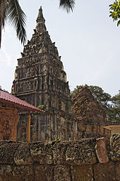
In the 11th century, the area belonged to the sphere of influence of the Khmer Empire of Angkor , as documented by ruins in the Khmer style such as the temple complex Ku Phra Kona .
In the 18th century, a Laotian prince emigrated with his followers from Champasak , only to settle in the area of today's Amphoe Suwannaphum in 1782. In Lao, the small principality was called Müang Thong at that time , which also means “gold city”. It thus belonged to the sphere of influence of the Kingdom of Champasak. Under Rama I (Phra Phutthayotfa Chulalok) the province of Roi Et was then brought under the direct control of Bangkok.
Administrative units
Provincial Administration
The district of Suwannaphum is divided into 15 tambon ("subdistricts" or "municipalities"), which are further subdivided into 199 Muban ("villages").
| No. | Surname | Thai | Muban | Pop. |
|---|---|---|---|---|
| 1. | Sa Khu | สระ คู | 21st | 20,505 |
| 2. | Doc May | ดอกไม้ | 14th | 6.178 |
| 3. | Well yai | นา ใหญ่ | 15th | 7,936 |
| 4th | Hin Kong | หิน กอง | 16 | 9,312 |
| 5. | Mueang Thung | เมือง ทุ่ง | 8th | 5,153 |
| 6th | Hua Thon | หัว โทน | 12 | 5,400 |
| 7th | Bo Phan Khan | บ่อ พัน ขัน | 9 | 4,550 |
| 8th. | Thung Luang | ทุ่ง หลวง | 15th | 7,975 |
| 9. | Hua Chang | หัว ช้าง | 12 | 6,284 |
| 10. | Nam Kham | น้ำ คำ | 16 | 9,517 |
| 11. | Huai Hin Lat | ห้วย หิน ลาด | 12 | 5,549 |
| 12. | Chang Phueak | ช้างเผือก | 11 | 6,861 |
| 13. | Thung Kula | ทุ่ง กุลา | 14th | 7,085 |
| 14th | Thung Si Mueang | ทุ่ง ศรี เมือง | 12 | 7,403 |
| 15th | Champa Khan | จำปา ขัน | 12 | 6,730 |
Local administration
There are six municipalities with "small town" status ( Thesaban Tambon ) in the district:
- Dok Mai (Thai: เทศบาล ตำบล ดอกไม้ ) consisting of the complete Tambon Dok Mai.
- Hin Kong (Thai: เทศบาล ตำบล หิน กอง ) consisting of the complete tambon Hin Kong.
- Thung Luang (Thai: เทศบาล ตำบล ทุ่ง หลวง ) consisting of the complete tambon Thung Luang.
- Thung Kula (Thai: เทศบาล ตำบล ทุ่ง กุลา ) consisting of the complete tambon Thung Kula.
- Champa Khan (Thai: เทศบาล ตำบล จำปา ขัน ) consisting of the complete tambon Champa Khan.
- Suwannaphum (Thai: เทศบาล ตำบล สุวรรณภูมิ ) consisting of parts of the tambon Sa Khu.
There are also ten " Tambon Administrative Organizations " ( องค์การ บริหาร ส่วน ตำบล - Tambon Administrative Organizations, TAO):
- Sa Khu (Thai: องค์การ บริหาร ส่วน ตำบล สระ คู ) consisting of parts of the tambon Sa Khu.
- Na Yai (Thai: องค์การ บริหาร ส่วน ตำบล นา ใหญ่ ) consisting of the complete tambon Na Yai.
- Mueang Thung (Thai: องค์การ บริหาร ส่วน ตำบล เมือง ทุ่ง ) consisting of the complete tambon Mueang Thung.
- Hua Thon (Thai: องค์การ บริหาร ส่วน ตำบล หัว โทน ) consisting of the complete Tambon Hua Thon.
- Bo Phan Khan (Thai: องค์การ บริหาร ส่วน ตำบล บ่อ พัน ขัน ) consisting of the complete tambon Bo Phan Khan.
- Hua Chang (Thai: องค์การ บริหาร ส่วน ตำบล หัว ช้าง ) consisting of the complete Tambon Hua Chang.
- Nam Kham (Thai: องค์การ บริหาร ส่วน ตำบล น้ำ คำ ) consisting of the complete Tambon Nam Kham.
- Huai Hin Lat (Thai: องค์การ บริหาร ส่วน ตำบล ห้วย หิน ลาด ) consisting of the complete tambon Huai Hin Lat.
- Chang Phueak (Thai: องค์การ บริหาร ส่วน ตำบล ช้างเผือก ) consisting of the complete tambon Chang Phueak.
- Thung Si Mueang (Thai: องค์การ บริหาร ส่วน ตำบล ทุ่ง ศรี เมือง ) consisting of the complete tambon Thung Si Mueang.
Individual evidence
- ↑ Askew, Long, Logan: Vientiane. Transformations of a Lao Landscape. 2007, p. 65.
- ↑ 2013 population statistics ( Thai ) Department of Provincial Administration. Retrieved August 3, 2014.
Web links
Coordinates: 15 ° 37 ' N , 103 ° 48' E

