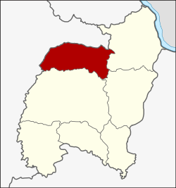
Senangkhanikhom district
|
Senangkhanikhom เสนางคนิคม |
|
|---|---|
| Province: | Amnat Charoen |
| Surface: | 526.0 km² |
| Residents: | 40,946 (2013) |
| Population density : | 76.4 U / km² |
| ZIP : | 37290 |
| Geocode : | 3705 |
| map | |

|
|
Amphoe Senangkhanikhom ( Thai : อำเภอ เสนางคนิคม ) is a district ( Amphoe - administrative district) in the north of the province of Amnat Charoen . The province of Amnat Charoen is located in the eastern part of the northeast region of Thailand , the so-called Isan .
geography
Neighboring Amphoe are counted from the east: the Amphoe Chanuman and Mueang Amnat Charoen of the province Amnat Charoen, as well as the Amphoe Thai Charoen and Thai Charoen in the province of Yasothon .
history
Senangkhanikhom was initially set up as a subdistrict ( King Amphoe ) on December 15, 1975 by separating the five tambon Senangkhanikhom, Rai Si Suk, Phon Thong, Nong Hai and Na Wiang from today's Amphoe Mueang Amnat Charoen . On April 1, 1983, Senangkhanikhom was promoted to Amphoe.
In 1993, Senangkhanikhom was one of the counties that was separated from Ubon Ratchathani to create the new Amnat Charoen Province.
administration
Provincial Administration
Amphoe Senangkhanikhom is divided into six tambon ("subdistricts" or "parishes"), which are further subdivided into 58 muban ("villages").
| No. | Surname | Thai | Muban | Pop. |
|---|---|---|---|---|
| 1. | Senangkhanikhom | เสนางคนิคม | 15th | 12,710 |
| 2. | Phon Thong | โพนทอง | 10 | 5,576 |
| 3. | Rai Si Suk | ไร่ สีสุก | 9 | 5,286 |
| 4th | Well Wiang | นา เวียง | 9 | 6,620 |
| 5. | Nong Hai | หนอง ไฮ | 9 | 6,483 |
| 6th | Nong Sam Si | หนอง สาม สี | 6th | 4,271 |
Local administration
There are two municipalities with "small town" status ( Thesaban Tambon ) in the district:
- Siri Senang (Thai: เทศบาล ตำบล สิริ เสนางค์ ) consisting of parts of the Tambon Senangkhanikhom.
- Senangkhanikhom (Thai: เทศบาล ตำบล เสนางคนิคม ) consisting of parts of the Tambon Senangkhanikhom.
There are five municipalities with "local government organization" status ( tambon administrative organizations ) in the county:
- Phon Thong (Thai: องค์การ บริหาร ส่วน ตำบล โพนทอง ) consisting of the complete Tambon Phon Thong.
- Rai Si Suk (Thai: องค์การ บริหาร ส่วน ตำบล ไร่ สีสุก ) consisting of the complete tambon Rai Si Suk.
- Na Wiang (Thai: องค์การ บริหาร ส่วน ตำบล นา เวียง ) consisting of the complete tambon Na Wiang.
- Nong Hai (Thai: องค์การ บริหาร ส่วน ตำบล หนอง ไฮ ) consisting of the complete Tambon Nong Hai.
- Nong Sam Si (Thai: องค์การ บริหาร ส่วน ตำบล หนอง สาม สี ) consisting of the complete tambon Nong Sam Si.
Individual evidence
- ↑ ประกาศ กระทรวง มหาดไทย เรื่อง แบ่ง ท้องที่ อำเภอ อำนาจเจริญ จังหวัด อุบลราชธานี ตั้ง เป็น กิ่ง อำเภอ เสนางค์ นิคม . In: Royal Gazette . 92, No. 259 ง , December 23, 1975, p. 3179.
- ↑ พระราชกฤษฎีกา ตั้ง อำเภอ เทพสถิต อำเภอ วังน้ำเย็น อำเภอ เนินมะปราง อำเภอ สวนผึ้ง และ อำเภอ เสนางคนิคม พ.ศ. ๒๕๒๖ . In: Royal Gazette . 100, No. 50 ก ฉบับ พิเศษ (special), March 31, 1983, pp. 10-12.
- ↑ 2013 population statistics . Department of Provincial Administration. Retrieved July 25, 2014.
Web links
Coordinates: 16 ° 2 ′ N , 104 ° 40 ′ E