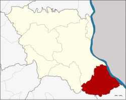
Don Tan district
|
Amphoe Don Tan อำเภอ ดอนตาล |
|
|---|---|
| Province: | Mukdahan |
| Surface: | 510.92 km² |
| Residents: | 43,392 (2013) |
| Population density : | 81.3 U / km² |
| ZIP : | 49120 |
| Geocode : | 4903 |
| map | |

|
|
Amphoe Don Tan ( Thai อำเภอ ดอนตาล ) is the southernmost administrative district ( Amphoe - Administrative District) of the Mukdahan Province . The province of Mukdahan is located in the eastern part of the northeast region of Thailand , the so-called Isan .
geography
Neighboring counties and areas are (clockwise from southeast): Amphoe Chanuman in Amnat Charoen Province , Amphoe Loeng Nok Tha in Yasothon Province , and Amphoe Nikhom Kham Soi and Mueang Mukdahan in Mukdahan Province. To the east on the other bank of the Mekong lies the Savannakhet province of Laos .
The main river in the district is the Mekong .
history
Originally Don Tan, a tambon ( "subdistrict" or "community") of the district Mueang Mukdahan in the province of Nakhon Phanom . In 1963 Don Tan was promoted to a "branch circle" ( King Amphoe ) , in 1974 to an Amphoe. When the new Mukdahan Province was created in 1982, Don Tan was one of the counties that originally made up the new province.
administration
Provincial Administration
Don Tan County is divided into seven tambon ("subdistricts" or "municipalities"), which are further subdivided into 63 Muban ("villages").
| No. | Surname | Thai | Muban | Pop. |
|---|---|---|---|---|
| 1. | Don Tan | ดอนตาล | 12 | 7,037 |
| 2. | Pho Sai | โพธิ์ ไทร | 7th | 4,676 |
| 3. | Pa Rai | ป่า ไร่ | 11 | 9,043 |
| 4th | Lao Wed | เหล่า หมี | 10 | 6,809 |
| 5. | Ban Bak | บ้าน บาก | 7th | 5,648 |
| 6th | Well seedg | นา สะ เม็ง | 9 | 7,260 |
| 7th | Ban Kaeng | บ้าน แก้ง | 7th | 2,919 |
Local administration
There are three municipalities with "small town" status ( Thesaban Tambon ) in the district:
- Don Tan (Thai: เทศบาล ตำบล ดอนตาล ) consists of parts of the Tambon Don Tan.
- Ban Kaeng (Thai: เทศบาล ตำบล บ้าน แก้ง ) consists of the entire tambon Ban Kaeng.
- Don Tan Pha Suk (Thai: เทศบาล ตำบล ดอนตาล ผาสุก ) consists of the remaining parts of the Tambon Don Tan.
There are also five " Tambon Administrative Organizations " ( องค์การ บริหาร ส่วน ตำบล - Tambon Administrative Organizations, TAO):
- Pho Sai (Thai: องค์การ บริหาร ส่วน ตำบล โพธิ์ ไทร )
- Pa Rai (Thai: องค์การ บริหาร ส่วน ตำบล ป่า ไร่ )
- Lao Mi (Thai: องค์การ บริหาร ส่วน ตำบล เหล่า หมี )
- Ban Bak (Thai: องค์การ บริหาร ส่วน ตำบล บ้าน บาก )
- Na Sameng (Thai: องค์การ บริหารส่วน ตำบล นา สะ เม็ง )
Individual evidence
- ↑ ประกาศ กระทรวง มหาดไทย เรื่อง แบ่ง ท้องที่ ตั้ง เป็น กิ่ง อำเภอ . In: Royal Gazette . 80, No. 14 ง , February 5, 1963, p. 221.
- ↑ พระราชกฤษฎีกา ตั้ง อำเภอ เขาวง อำเภอ เชียงม่วน อำเภอ ดอนตาล อำเภอ ชาติตระการ อำเภอ ภูเรือ อำเภอ เคียน ซา อำเภอ น้ำโสม อำเภอ หนองวัวซอ และ อำเภอ น้ำยืน พ.ศ. ๒๕๑๗ . In: Royal Gazette . 91, No. 54 ก ฉบับ พิเศษ , March 28, 1974, pp. 30-33.
- ↑ พระราชบัญญัติ ตั้ง จังหวัด มุกดาหาร พ.ศ. ๒๕๒๕ . In: Royal Gazette . 99, No. 121 ก ฉบับ พิเศษ , August 27, 1982, pp. 14-17.
- ↑ 2013 population statistics ( Thai ) Department of Provincial Administration. Retrieved July 31, 2014.
Web links
Coordinates: 16 ° 19 ′ N , 104 ° 55 ′ E