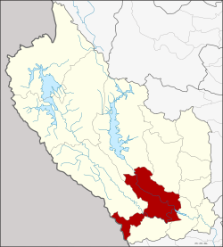
Amphoe Mueang Kanchanaburi
|
Mueang Kanchanaburi เมือง กาญจนบุรี |
|
|---|---|
| Province: | Kanchanaburi |
| Surface: | 1236.28 km² |
| Residents: | 159,636 (2013) |
| Population density : | 124.2 U / km² |
| ZIP : | 71000, 71190 |
| Geocode : | 7101 |
| map | |

|
|
Amphoe Mueang Kanchanaburi ( Thai อำเภอ เมือง กาญจนบุรี ) is a district ( Amphoe - Administrative District) in Kanchanaburi Province . Kanchanaburi Province is located in the far west of the central region of Thailand .
geography
Neighboring districts are (from west clockwise) Tanintharyi Division in Myanmar and Amphoe Sai Yok , Si Sawat , Bo Phloi , Tha Muang and Dan Makham Tia Kanchanaburi province and Amphoe Suan Phueng of Ratchaburi province .
history
As early as the Stone Age, the area was a retreat for members of the Hoabinhian culture and home to Neolithic farmers, as excavations near Ban Kao have shown (see Khao Talu Cave and Ban Kao National Museum ).
The city ( Mueang ) Kanchanaburi was relocated to its present location in 1833 under King Phra Nang Klao ( Rama III ) (called Pak Phraek at the time) after it had been largely destroyed by the Burmese at the end of the 18th century. Before that it was about 8 km northwest of the current location.
In 1913, Mueang Kanchanaburi was raised to the district (Amphoe Mueang) of Kanchanaburi Province. The administration was initially located on Lak Mueang Road, Tambon Ban Nuea. On October 1, 1954, it was moved to its present location, Sang Chuto Road in Tambon Pak Phraek.
education
The Rajabhat University of Kanchanaburi is located in Amphoe Mueang Kanchanaburi .
administration
Provincial Administration
Mueang Kanchanaburi County is divided into 13 tambon ("subdistricts" or "parishes"), which are further subdivided into 101 muban ("villages").
| No. | Surname | Thai | Muban | Pop. |
|---|---|---|---|---|
| 1. | Ban Nuea | บ้าน เหนือ | - | 10,791 |
| 2. | Ban Tai | บ้าน ใต้ | - | 6,417 |
| 3. | Pak Phraek | ปาก แพรก | 13 | 30,872 |
| 4th | Tha Makham | ท่า มะขาม | 5 | 13,902 |
| 5. | Kaeng Sian | แก่ง เสี้ยน | 9 | 11.051 |
| 6th | Nong Bua | หนองบัว | 8th | 11.303 |
| 7th | Lat Ya | ลาด หญ้า | 7th | 27,820 |
| 8th. | Wang Dong | วัง ด้ง | 12 | 8,419 |
| 9. | Chong Sadao | ช่อง สะเดา | 7th | 3,645 |
| 10. | Nong Ya | หนอง หญ้า | 9 | 7,669 |
| 11. | Ko Samrong | เกาะ สำโรง | 9 | 8,756 |
| 13. | Ban Kao | บ้าน เก่า | 15th | 13,284 |
| 16. | Wang Yen | วัง เย็น | 7th | 5,707 |
Local administration
There is one commune with "city" status ( Thesaban Mueang ) in the district:
- Kanchanaburi (Thai: เทศบาล เมือง กาญจนบุรี ) consisting of the complete tambon Ban Nuea, Ban Tai and parts of the Tambon Pak Phraek, Tha Makham and parts of the Tambon Tha Lo from the neighboring Amphoe Tha Muang .
There are five municipalities with "small town" status ( Thesaban Tambon ) in the district:
- Tha Makham (Thai: เทศบาล ตำบล ท่า มะขาม ) consisting of parts of the Tambon Tha Makham.
- Kaeng Sian (Thai: เทศบาล ตำบล แก่ง เสี้ยน ) consisting of parts of the Tambon Kaeng Sian.
- Lat Ya (Thai: เทศบาล ตำบล ลาด หญ้า ) consisting of parts of the Tambon Lat Ya.
- Nong Bua (Thai: เทศบาล ตำบล หนองบัว ) consisting of parts of the Tambon Nong Bua.
- Pak Phraek (Thai: เทศบาล ตำบล ปาก แพรก ) consisting of parts of the Tambon Pak Phraek.
In addition, there are nine " tambon administration organizations " ( องค์การ บริหาร ส่วน ตำบล - Tambon Administrative Organizations, TAO)
- Kaeng Sian (Thai: องค์การ บริหาร ส่วน ตำบล แก่ง เสี้ยน ) consisting of parts of the Tambon Kaeng Sian.
- Nong Bua (Thai: องค์การ บริหาร ส่วน ตำบล หนองบัว ) consisting of parts of the Tambon Nong Bua.
- Lat Ya (Thai: องค์การ บริหาร ส่วน ตำบล ลาด หญ้า ) consisting of parts of the Tambon Lat Ya.
- Wang Dong (Thai: องค์การ บริหาร ส่วน ตำบล วัง ด้ง ) consisting of the complete tambon Wang Dong.
- Chong Sadao (Thai: องค์การ บริหาร ส่วน ตำบล ช่อง สะเดา ) consisting of the complete tambon Chong Sadao.
- Nong Ya (Thai: องค์การ บริหาร ส่วน ตำบล หนอง หญ้า ) consisting of the complete Tambon Nong Ya.
- Ko Samrong (Thai: องค์การ บริหาร ส่วน ตำบล เกาะ สำโรง ) consisting of the complete tambon Ko Samrong.
- Ban Kao (Thai: องค์การ บริหาร ส่วน ตำบล บ้าน เก่า ) consisting of the complete tambon Ban Kao.
- Wang Yen (Thai: องค์การ บริหาร ส่วน ตำบล วัง เย็น ) consisting of the complete tambon Wang Yen.
Individual evidence
- ^ Barend Jan Terwiel : Through Travelers' Eyes: an approach to early nineteenth century Thai history . Bangkok: Ed. Duang Kamol 1989. ISBN 974-210-455-7 , p. 95.
- ↑ 2013 population statistics ( Thai ) Department of Provincial Administration. Retrieved September 10, 2014.
Web links
- More information on Amphoe Mueang Kanchanaburi from amphoe.com (in Thai; last accessed December 1, 2015)
Coordinates: 14 ° 1 ' N , 99 ° 32' E
