Kayin state
Coordinates: 19 ° 13 ' N , 97 ° 24' E
|
ကရင်ပြည်နယ် Kayin State |
|

|
|
| Capital | Hpa-an |
| surface | 30,382.77 km² |
| population | 1,574,079 (2014) |
| Population density | 51.8 inhabitants per km² |
| ethnicities |
Karen (Kayin), Padaung , Bamar , Shan , Pa-O , Mon , Rakhine |
The Kayin State ( Burmese ကရင်ပြည်နယ် , BGN / PCGN : kayinbyinè), also known as Karen State , is one of the 15 administrative units of Myanmar . It is named after the Karen (Kayin) people.
geography
The Kayin State is in the east of Myanmar. It borders the Mandalay region to the north and the Bago region and the Mon State to the west . In the northeast it borders the Kayah State , and in the east it forms the state border with Thailand and here borders the provinces of Kanchanaburi , Tak and Mae Hong Son . The capital of the Kayin State is Hpa-an .
population
The majority of the population is made up of the Karen people, who came from Mongolia 2700 years ago via Tibet, following the Saluen River , and settled what is now the Kayin State. Other Karen groups followed the Mekong and Irrawaddy . Many Karen people in present-day Myanmar settle outside of the Karen state, especially in the Yangon and Tanintharyi regions , but also in the Mon state .
history
The Kayin State is the site of the longest-running nationality conflict on earth. Since Myanmar gained independence in 1948, the Karen National Union (KNU) has been fighting for an independent country called Kawthoolei . The Myanmar military government, also known as the State Council for Peace and Development , has invested very little in state infrastructure such as schools, clinics and hospitals in the past. The majority of the population sees the KNU as the actually legitimate government of the Kayin state. The central government is trying to break resistance in the mountainous state with resettlements. There were also conflicts between Christian and Buddhist Karen ( Democratic Karen Buddhist Army ). Since 2006 the army has been intensifying its offensive against the KNU, in the course of which hundreds of villages have been destroyed and tens of thousands of civilians have been displaced.
Many people from Kayin State live in refugee camps in the Thai border provinces of Kanchanaburi, Mae Hong Son and especially in Mae Sot . Hundreds of thousands hide in the jungle from the attack of the Myanmar army.
Districts
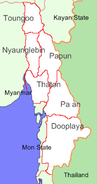
Kayin State is divided into 6 districts.
- Toungoo District
- Nyaunglebin District
- Papun District
- Thaton District
- Pa'an District
- Dooplaya District


