
Magwe region
Coordinates: 20 ° 16 ' N , 94 ° 47' E
|
မကွေးတိုင်းဒေသကြီး Magwe region |
|

|
|
| Capital | Magwe |
| surface | 44,820.58 km² |
| population | 3,917,055 (2014) |
| Population density | 87.4 inhabitants per km² |
| ethnicities |
Bamar , Chin , Arakanese , Shan , Karen |
  |
|
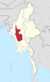
The Magwe region ( Burmese မကွေးတိုင်းဒေသကြီး , BGN / PCGN : magwedaingdethagyi , until 2008 Magwe division ), also written Magway , is one of the 15 administrative units of Myanmar (Burma).
geography
Magwe lies between the Sagaing region in the north, the Mandalay region in the east, the Bago region in the south and the states of Arakan (Rakhaing) and Chin in the west between 18 ° 50 'and 22 ° 47' north latitude and 93 ° 47 'and 95 ° 55' E longitude. With an area of 44,820.58 km², the Magwe region is the third largest region after the Sagaing and Bago regions, and it ranks fifth among all the states and regions of Myanmar.
Magwe is located in the central basin of the Irawadi , which, coming from Sagaing, forms the border to the neighboring Mandalay region in the northeast after merging with the Chindwin up to near the city of Chauk and then flows through the Magwe region in a southerly direction and thus flows through it fairly precisely divides into an east and west half.
The vast majority of it is made up of the vast plains that the Irrawaddy has created over the course of millions of years. To the west, the Arakan-Yoma mountain range forms a natural border with the Arakan and Chin states with elevations of up to just over 3000 m ; in the east, the hills of the Bago Yomas with heights of up to 500 m limit the region to the Mandalay region.
population
The population at the beginning of 2005 was 5,118,000. 96.7% belong to the Burmese (Bamar) ethnic group, 2.4% the Chin, 0.1% are Arakanese (Rakhine). The remaining 0.8% is shared by Karen, Shan and others. In 2014, the census determined a population of 3,917,055 people. The proportion of the rural population was 85%.
The majority of the residents are Buddhists (98.9%), 0.4% Christians , 0.3% Muslims and 0.1% Hindu .
climate
The Arakan-Yoma mountain range in the west prevents excessive rainfall. The majority of the Magwe region lies in the dry zone and has a steppe climate - hot in the warm season and relatively cold in the cold. The average temperature in April, the hottest month, is 32 ° C and can rise to over 43 ° C. The average in the coolest month of January is 21 ° C with temperatures as low as 10 ° C.
administration
The Magwe region is divided into the districts of Magwe , Minbu , Thayet , Pakokku and Gangaw , which comprise 25 parishes and 1,696 parishes. The capital, like the region, bears the name Magwe , its estimated population on January 1, 2005 was 96,966. Other cities are Pakokku in the northeast (126,954 inhabitants), Yenangyaung , between Chauk and Magwe, (110,567), Thayetmyo in the south (98,197), Chauk at the westernmost tip of the Mandalay region (90,882) and Taungdwingyi , southeast of Magwe, (70,103) . The city of Natmauk , about 50 km northeast of the capital Magwe, is the birthplace of the founder of Burma's independence from Great Britain, General Aung San .
economy
Primarily oil and natural gas are produced in the Magwe region . The daily output of the oil fields in Mann, Yenangyaung, Chauk, Kyauk-khwet, Letpando and Ayadaw is more than 8000 barrels and is thus at the top in all of Burma. Natural gas is produced in Pay-ye near the city of Thayetmyo.
Other branches of industry of importance are cotton weaving mills , tobacco growing , iron and bronze mining, cement production and agriculture.
Magwe produces edible oil from peanut and sesame cultivation on a large scale and therefore has the unofficial title of Burma's 'oil can'. Other products are millet , corn , sunflowers and legumes, as well as chilli, onions and potatoes, as well as rice , thanks to artificial irrigation .
In addition, the Indian crab apple or Thanaka tree ( Limonia acidissima , Feronia elephantum ), and Phangar, a stone fruit that is used in Ayurvedic medicine under the name Haritaki ( Terminalia chebula Retz.) , Are cultivated. The bark of the thanaka tree is used to make thanaka , a whitish-yellow paste that is applied to the skin as a cosmetic.
Tourism is of secondary importance in the Magwe region .
history
In 1978, Burmese archaeologists discovered the remains of ancient primates in the Pondaung area on the border with the Sagaing Division in the northeast , estimated to be 40 million years old. It is said to have been an animal the size of a small monkey. The species was named Bahinia pondaungensis , according to its location near the village of Ba-in.
The find was valuable for archeology insofar as it allowed earlier finds in China to be clearly assigned to primates. If it was previously assumed that man's origins lie on the African continent, now one had to consider looking for it in Asia. After further Pondaung expeditions, the military regime in Rangoon presented the find from 1997 as proof that the cradle of mankind was in Burma.
Excavations near the city of Taungdwingyi in the late 1950s uncovered the remains of the ancient city-state of Beikthano . The archaeological findings come to the conclusion that the Pyu civilization experienced its first heyday here in the first 5 centuries AD .
During the time of British rule, the area of today's Magwe Division belonged to Upper Burma. Up until 1940 the division was named Minbu-Division after the city of the same name not far from Magwe. In the 1960s, Yenangyaung temporarily became the capital of the Magwe Division.