Sam Ngao district
|
Sam Ngao สามเงา |
|
|---|---|
| Province: | Tak |
| Surface: | 2,771.927 km² |
| Residents: | 32,176 (2012) |
| Population density : | 12 U / km² |
| ZIP : | 63130 |
| Geocode : | 6303 |
| map | |

|
|

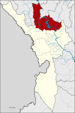
Amphoe Sam Ngao ( Thai : อำเภอ สามเงา ) is a district ( amphoe - administrative district) in Tak Province . The Tak Province is located in the northern region of Thailand .
location
Amphoe Sam Ngao is located in the extreme northeast of Tak Province and borders three other provinces in the country, Chiang Mai , Lamphun and Lampang .
history
Amphoe Sam Ngao was first established in 1930 as a small district ( King Amphoe ) in the Amphoe Ban Tak . If the name was initially Tha Pui ( ท่า ปุย ), the King Amphoe was renamed in 1939 to the current name Sam Ngao. In 1958 it was upgraded to a full amphoe.
geography
Amphoe Sam Ngao is located in the northeast of the Tak Province and, when viewed clockwise from the south, borders on the Ban Tak and Mae Ramat Amphoe in the Tak Province, Omkoi and Doi Tao in the Chiang Mai Province , Thung Hua Chang in the Lamphun Province and Mae Phrik and Thoen in Lampang Province .
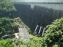
The main water sources for agricultural use in the amphoe are the Mae Nam Ping and Mae Nam Wang rivers . The Bhumibol Dam forms an artificial lake with an area of around 300 km², which on the one hand is intended to prevent flooding and , on the other hand, is Thailand's most powerful hydropower plant and supplies electricity. Much of the district is taken up by Mae Ping National Park.
administration
Provincial Administration
Amphoe Sam Ngao consists of 6 sub-districts ( tambon ), which are further divided into 43 villages ( muban ).
| No. | Surname | Thai | Muban | |
|---|---|---|---|---|
| 1. | Sam Ngao | สามเงา | 5 | 8,750 |
| 2. | Wang Man | วัง หมัน | 7th | 4,517 |
| 3. | Yokkrabat | ยกกระบัตร | 2 | 8,220 |
| 4th | Yan Ri | ย่าน รี | - | 3,313 |
| 5. | Ban Na | บ้านนา | 12 | 2,094 |
| 6th | Wang Chan | วัง จันทร์ | 10 | 5,282 |
Note: Some of the Muban's data are not yet available.
Local administration
Sam Ngao (Thai: เทศบาล ตำบล สามเงา ) is a small town ( Thesaban Tambon ) in the district, it consists of parts of the Tambon Sam Ngao.
There are also six "Tambon Administrative Organizations" (TAO, องค์การ บริหาร ส่วน ตำบล - administrative organizations) for the tambon in the district that do not belong to any city.
Individual evidence
- ↑ พระราชกฤษฎีกา เปลี่ยน นาม อำเภอ กิ่ง อำเภอ และ ตำบล บาง แห่ง พุทธศักราช ๒๔๘๒ . In: Royal Gazette . 56, No. 0 ก , April 17, 1939, pp. 354-364.
- ↑ พระราชกฤษฎีกา จัดตั้ง อำเภอ กระสัง ... . In: Royal Gazette . 75, No. 55 ก , July 22, 1958, pp. 321-327.
- ↑ Population statistics 2012 . Department of Provincial Administration. Retrieved June 25, 2014.
Web links
Coordinates: 17 ° 15 ' N , 99 ° 1' E

