
Mae Nam Ping
|
Mae Nam Ping Ping |
||
 |
||
| Data | ||
| location | Northern Thailand | |
| River system | Mae Nam Chao Phraya | |
| Drain over | Mae Nam Chao Phraya → Gulf of Thailand | |
| source | Chiang Dao National Park, district Chiang Dao , Province Chiang Mai 19 ° 18 '10 " N , 98 ° 57' 31" O |
|
| muzzle | Confluence with the Mae Nam Nan at Nakhon Sawan to the Chao Phraya Coordinates: 15 ° 42 ′ 3 ″ N , 100 ° 8 ′ 32 ″ E 15 ° 42 ′ 3 ″ N , 100 ° 8 ′ 32 ″ E
|
|
| length | 569 km | |
| Catchment area | 33,896 km² | |
| Reservoirs flowed through | Bhumibol Dam | |
 The ping in Chiang Mai Province |
||
The Mae Nam Ping ( Thai : แม่น้ำ ปิ ง , "Ping River") is one of the four great rivers of northern Thailand , the other three are Mae Nam Wang , Mae Nam Yom and Mae Nam Nan . Together with the Nan, the Ping at Nakhon Sawan forms the Mae Nam Chao Phraya , Thailand's largest river.
The ping is 569 km long, its sources lie in the mountains of Pha Daeng National Park (also: National Park Chiang Dao) in the northern part of the district of Chiang Dao , Province of Chiang Mai . After passing the provincial capital of the same name , it flows through the provinces of Lamphun , Tak and Kamphaeng Phet . At the confluence with the Mae Nam Nan at Nakhon Sawan , they together form the Mae Nam Chao Phraya.
About halfway between Chiang Mai and the mouth, in the north of Tak Province, the Ping is dammed at the Bhumibol Dam . This makes it the largest reservoir in Thailand with a surface area of 300 km².

On the banks of the Ping in Chiang Mai
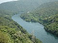
The ping below the Bhumibol dam

Confluence of the Ping and Nan rivers to the Chao Phraya


Web links
- Mae Ping River - Lifeline of Chiangmai Province : Description of the sights along the river (last accessed August 1, 2015; in English)
literature
- Steve Van Beek: Slithering South . Bangkok: Wind & Water 2002. ISBN 974-619-074-1 (travel report of the well-known journalist who did the entire ping in his own paddle boat and paddled on over the Chao Phraya to Bangkok).