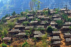
Amphoe Tha Song Yang
|
Tha Song Yang ท่าสองยาง |
|
|---|---|
| Province: | Tak |
| Surface: | 1,920.38 km² |
| Residents: | 63,932 (2012) |
| Population density : | 32 U / km² |
| ZIP : | 63150 |
| Geocode : | 6305 |
| map | |

|
|
Amphoe Tha Song Yang ( Thai อำเภอ ท่าสองยาง ) is a county ( amphoe - administrative district) in Tak Province . The Tak Province is located in the northern region of Thailand .
etymology
Tha Song Yang means a landing place on the river, which is surrounded by two Yang trees ( Dipterocarpus sp. , Wing fruit family ). The name comes from the old district administration by the river, where there was a yang tree on each side of the river.
geography
Amphoe Tha Song Yang is located in the far northwest of the Tak Province and borders the Mae Hong Son and Chiang Mai provinces as well as Myanmar .
Tha Song Yang District is located in the extreme northwest of the province of Tak and borders from the northwest clockwise as seen in the Amphoe Sop Moei in Mae Hong Son province , Amphoe Omkoi the province Chiang Mai and Amphoe Mae Ramat in Tak Province. To the west on the opposite bank of the Moei River lies the Kayin State of Myanmar .
An important waterway in the district is the Maenam Moei (Moei River) .
history
Tha Song Yang was formerly a small district ( King Amphoe ) in Mae Sariang District (Mae Hong Son Province) and was called Ban Mae Moei ( บ้าน แม่ เมย ) or Ban Mae Tawo ( บ้าน แม่ ตะ วอ ) at that time . The district administration was in Tambon Tha Song Yang.
In 1948 the area was incorporated into Mae Sot County, Tak Province. The following year the county government moved to Tambon Mae Tan. Eventually, Tha Song Yang was upgraded to an Amphoe in 1958 .
Mae La refugee camp
Mae La (Maela) is a refugee camp in Thailand. The camp has existed since 1984 in Tha Song Yang Amphoe, Dawna Range area and currently houses 30,000 refugees . The refugee camp is the largest Burmese refugee camp. Over 90% are ethnic Karen .
Attractions
-
National parks :
- Mae Moei National Park (Thai: อุทยานแห่งชาติ แม่ เมย ) 185.28 km² park, opened in 1990, average height 680 meters, with numerous waterfalls and caves and a "Sea of Fog" ( จุด ชม ทะเล หมอก ) called viewpoint, which is often in the fog lies.
administration
Provincial Administration
Amphoe Tha Song Yang consists of six sub-districts ( tambon ) , which are further divided into 66 villages ( muban ) .
| No. | Surname | Thai | Muban | Pop. |
|---|---|---|---|---|
| 1. | Tha Song Yang | ท่าสองยาง | 9 | 8,942 |
| 2. | Mae Tan | แม่ ต้าน | 10 | 10,995 |
| 3. | Mae Song | แม่ สอง | 16 | 15,389 |
| 4th | Mae La | แม่ หละ | 12 | 8,060 |
| 5. | Mae Wa Luang | แม่ วะ หลวง | 9 | 6,274 |
| 6th | Mae U-su | แม่ อุสุ | 10 | 14,272 |
Local administration
Mae Tan (Thai: เทศบาล ตำบล แม่ ต้าน ) is a small town ( Thesaban # small town ) in the district, it consists of parts of the Tambon Mae Tan.
There are also six "Tambon Administrative Organizations" (TAO, องค์การ บริหาร ส่วน ตำบล - administrative organizations) for the tambon in the district that do not belong to any city.
Individual evidence
- ↑ พระราชบัญญัติ เปลี่ยนแปลง เขต จังหวัด แม่ฮ่องสอน และ จังหวัด ตาก พ.ศ. ๒๔๙๑ . In: Royal Gazette . 65, No. 43 ก , July 27, 1948, pp. 452-454.
- ↑ ประกาศ กระทรวง มหาดไทย เรื่อง ย้าย ที่ว่าการ กิ่ง อำเภอ ท่าสองยาง อำเภอ แม่สอด จังหวัด ตาก . In: Royal Gazette . 66, No. 52 ง , September 20, 1949, pp. 4387-4388.
- ↑ พระราชกฤษฎีกา จัดตั้ง อำเภอ กระสัง ... . In: Royal Gazette . 75, No. 55 ก , July 22, 1958, pp. 321-327.
- ↑ UNHCR Thailand and Japan Pilot Resettlement Program (PDF; 272 kB) August 25, 2010
- ↑ Thailand Burma Border Consortium (TBBC): Information on Mae La ( Memento of the original of September 3, 2011 in the Internet Archive ) Info: The archive link was automatically inserted and not yet checked. Please check the original and archive link according to the instructions and then remove this notice.
- ↑ Population statistics 2012 . Department of Provincial Administration. Retrieved June 25, 2014.
Web links
- More details on Amphoe Tha Song Yang from amphoe.com (in Thai)
- Information on Mae Moei National Park from dnp.go.th (in English)
- Thailand Burma Border Consortium (TBBC): For information on Mae La (in English)
Coordinates: 17 ° 14 ' N , 98 ° 14' E

